
Terskej-Alatau
| Terskej-Alatau | ||
|---|---|---|
 Terskej-Alatau |
||
| Highest peak | Karakol Peak ( 5216 m ) | |
| location | Issyk Kul , Naryn ( Kyrgyzstan ) | |
| Mountain range of the | Tianshans | |
|
||
| Coordinates | 42 ° 10 ′ N , 78 ° 28 ′ E | |

The Terskej-Alatau ( Kyrgyz Тескей Ала-Тоо ; Russian Терскей-Алатау ) is a high mountain range in Kyrgyzstan ( Central Asia ) up to 5216 m .
The Terskej-Alatau, which is a partial mountain range of the Tianshan , is located in the east of Kyrgyzstan south of the large lake Issykköl . In the east and southeast it merges into the Kokschaal Tau Mountains ( 7439.3 m ), which contain the highest peaks of the Tianshan. To the south, the mountain landscape merges almost seamlessly over high mountain valleys into the Kuiljutau Mountains ( 5281 m ). To the south and south-west the mountains descend to the Naryn valley . Further high mountains in Kyrgyzstan connect to the west. The Terskej-Alatau extends over a length of 375 km.
The Kyrgyzstan Trail runs through Terskej-Alatau , a long-distance hiking trail redesigned in 2007 that opens up and connects the mountain ranges of the Issyk-Kul region in Kyrgyzstan.
mountains
The highest mountain in Terskej-Alatau is Pik Karakol ( 5216 m ). Other important mountains are Pik Dschigit ( 5170 m ), Pik Jelzin (formerly Ogus-Baschi ; 5168 m ) and Pik Bljuchera ( 4780 m ).
Attractions
The sandstone cliffs Seven Bulls near the village of Dscheti-Ögüs , the hot springs of Altyn Araschan and the mountain lake Alaköl are worth seeing .
gallery
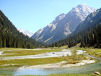
Karakol river valley
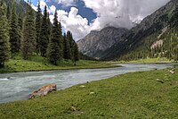
Karakol river valley

Rock Seven bulls near Dscheti-Ögüs


Web links
literature
- Kay Tschersich: Kyrgyzstan, Terskej-Alatau-Traverse from Kyzyl Suu to Ak Suu, trekking in Tienschan (= OutdoorHandbuch. Volume 151). Conrad Stein Verlag, Welver 2005, ISBN 3-89392-551-1 .
Individual evidence
- ↑ Topomapper
- ↑ Article Terskej-Alatau in the Great Soviet Encyclopedia (BSE) , 3rd edition 1969–1978 (Russian)