Signature (cartography)
A signature in cartography is a generalizing, partially standardized graphic symbol for the representation of objects and facts in maps . In the case of more precise (large-scale) plans , one also speaks of plan signs .
The basic types of signature forms
Signatures are only set if the surfaces characterized with them (or their appearance) have been recorded by surveying the terrain , by inspection, aerial photographs or other data acquisition systems .
In general, signatures are divided into:
- Point signatures
- Line signatures
- Area signatures
In addition, a distinction is made between the signature forms :
- Discrete : objects that can be clearly separated from one another in space, such as B. fields or bodies of water.
- Continua : objects continuously distributed over a map, such as B. Terrain representations or representations of the height relationships by contour lines.
Point or figure signatures
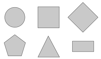
Point signatures represent location-specific objects or facts, which can be designed either concrete or abstract. When depicting quantitative aspects, the size scaling of the point signatures is used to reproduce values that follow a certain signature scale. Well-known examples of point signatures are geometric representations such as triangles, rectangles or circles (about 0.5 mm in size from printed maps), for example for surveying or height points and additionally with a cross for churches . There are also speaking point signatures, for example for mountain huts , signposts, memorials and conspicuous trees.
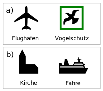
Concrete or speaking signature forms
Under concrete or speaking signature forms one understands symbolism whose content itself is speaking. Above all, they are suitable to represent qualitative facts. In principle, a distinction is made between floor plan and elevation representations , whereby there are a number of elevation signatures, as it is easier for people, because they are more accustomed to see large objects in this projection, for example the house silhouette as a symbol for buildings. An example of a signature where the floor plan is more familiar and more expressive than the elevation is the airplane as a symbol for airports. Concrete signatures are particularly suitable for reproducing objects that are spread over a point or area.
In addition to the great advantage of the very good mnemonic properties of this type of signature, there are above all several disadvantages, which are the reason why this signature form, which was very popular in the past, is used less often today. The main disadvantages are the highly resolved outlines, which make this signature form more difficult to read in clustered areas, the limited possibility of quantitative statements with a size-based scaling, the limited ability to group and combine and the limited scope for the choice of signature in clustered areas for overlap to avoid.
Abstract or geometric signature shapes
In the case of abstract or geometric signature shapes, one usually speaks of the basic geometric shapes, such as the circle , the rectangle or the triangle . However, evenly arranged points or lines as well as other symmetrical figures are geometric signatures.
Abstract signature forms have a more limited variety and fewer mnemonic properties than concrete signatures, but are easier to read and differentiate due to their clear design. Typically, they are specified in a more diverse way by adding small additional symbols, such as the symbol ♁ for churches.
In addition, unlike concrete signatures, they can be used to the same extent as a means of expression for linear objects as well as for point and area objects. Another advantage is the optimal suitability for a quantitative representation, since the clear shape enables a good, comparable and assessable size scale to be produced. Furthermore, geometric symbol shapes are very suitable for groups and combinations.
Line or band signatures
In addition to linear discrete and continua, line signatures can also demarcate flat discrete such as various areas of distribution and occurrence according to their ground plan. Lines are called a signature if they have a meaningfulness in relation to the represented qualitative or quantitative facts. In contrast to point-like signatures, line signatures are extremely limited in their variety. Line signatures are primarily understood to mean solid, dotted or dashed lines, but also vectors, movement or direction arrows.
There are also special line structures and hatchings with which, for example, embankments , the edges of quarries or steep river banks are displayed.
Area signatures
Area signatures are those objects that have an areal distribution and are often delimited by a line signature. In order for these objects to be clearly legible, they must be clearly closed in order to distinguish themselves from other two-dimensional objects. Possibilities to follow this principle are the use of surface grids, structure grids, surface patterns ( hatching and other simple graphic elements tiled together ) or surface coloring.
Areas with a particularly uniform character are designed in a grid shape or with matching colors, e.g. B. for forest areas , bushes or moors , for fields, vineyards , meadows or cemeteries .
Group and combination ability of signatures
The group ability describes the possibility of developing secondary forms for signatures while maintaining the basic form or other basic elements such as the grid, the color or the line width. The changes in relation to the initial shape should be relatively small in order to visually identify these signatures as belonging together as well as possible. Such groupings are made when you want to display different objects, but these are to be assigned to a higher-level issue, for example.
The ability to combine signatures is understood to mean the possibility of developing secondary forms by combining two or more basic forms or form elements. Such combinations of different basic forms are made when different facts occur together in one place.
For example, it is easier to superimpose patterns and colors.
The signature scale
The signature scale tries to bring the quantitative values represented on a map by means of signatures into a uniform scaling. The principle is followed that the size of the value to be displayed correlates with the signature size. When adapting the signatures to the values to be displayed, a distinction is usually made between four standards that can be used:
- a) Strictly proportional continuous measures
- b) Strictly proportional graduated standards
- c) Arbitrarily continuous measures
- d) Arbitrarily tiered standards
In the case of strictly proportional scaling, the size of the signature changes with the same factor as the magnification of the object to be displayed. However, if the values to be displayed diverge so strongly that an appealing display is made impossible, arbitrary scales are normally used so as not to destroy the design image of the map. The advantage of continuous scales lies in the good quantitative measurability, while the advantage of graduated signature scales lies in the ability to quickly understand various positionally correct quantitative absolute representations.
Standardized signatures
Nautical chart
The symbols in the nautical charts are internationally standardized by the IHO .
-
Paper map
- Nautical signs according to International Map 1 ( INT 1 ) are shown on paper maps .
-
Electronic nautical chart
- In the electronic nautical chart (ECDIS) , the navigation marks are shown according to the international standard S-52 (symbols) and S-57 (object catalog) .
See also
- Rock drawing (cartography)
- Character key (legend)
- In Unicode Block Various symbols ( Miscellaneous Symbols ) are different card characters (♁: church ⚐: Start, ⚑: goal ⚒: Mining, ⚓ Harbor, ⚔: battle ⚕: pharmacy, ⚖: court ⚛: Nuclear power plant )
literature
- Erik Arnberger : Thematic cartography (= the geographical seminar ). 1st edition. Georg Westermann Verlag, Braunschweig 1977, ISBN 3-14-160300-6 .
- Eduard Imhof : Thematic cartography (= textbook of general geography . Volume 10 ). Walter de Gruyter, Berlin / New York 1972, ISBN 3-11-002122-6 .
- Rudi Ogrissek (Ed.): ABC Kartenkunde . 1st edition. Brockhaus Verlag, Leipzig 1983, ISBN 3-87144-784-6 .
- Günter Hake, Dietmar Grünreich, Liqiu Meng: Cartography: Visualization of space-time information . 8th edition. Walter de Gruyter, Berlin / New York 2002, ISBN 3-11-016404-3 .
Individual evidence
- ↑ a b c signatures , online at gis1.de, on June 23, 2009; As of January 30, 2010.
- ↑ Section B-300 (Topography) ( Page no longer available , search in web archives ) Info: The link was automatically marked as defective. Please check the link according to the instructions and then remove this notice. (PDF; 13.5 MB)


