
Comino
| Comino | ||
|---|---|---|
 |
||
| Waters | Mediterranean Sea | |
| Geographical location | 36 ° 0 ′ 40 ″ N , 14 ° 20 ′ 19 ″ E | |
|
||
| length | 2.6 km | |
| width | 2.1 km | |
| surface | 3 km² | |
| Highest elevation | Redoubt Hill 75 m |
|
| Residents | 3 (2017) 1 inh / km² |
|
| main place | Comino | |
 |
||

Comino , derived from the Maltese word Kemmuna ( German caraway ), is the smallest inhabited island in the Maltese archipelago . It belongs to the municipality of Għajnsielem in the southeast of Gozo . The island can be reached from the ferry ports in Għajnsielem ( Mġarr ) on Gozo and Ċirkewwa on Malta .
geography
Comino is located between the two larger Maltese islands of Malta in the south and Gozo in the north in the Il-Fliegu ta 'Ghawdex estuary, about six kilometers wide . The island is about three square kilometers and a rocky plateau protruding from the sea between ten and twenty meters. The coast drops steeply almost everywhere and is interspersed with numerous caves.
nature
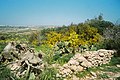
The vegetation on Comino is sparse. Every now and then you come across small Aleppo pines and oleander bushes , only the agaves and prickly pear cacti reach normal dimensions. After a damp winter, the ground can be covered in copious amounts of heather, thyme, and various hard grasses. Comino is also a haven for birds.
history
In ancient times the island was also called "Ephestia". Comino was already settled in the Bronze Age, graves from the Punic - Phoenician era were found on the west coast. In the Middle Ages up to 200 people lived on the island and the caraway, which gave the island its name, was grown . During this time Comino was a base for pirates who found convenient hiding spots on the cave-rich coast. They were driven out by the Johanniter at the beginning of the 17th century . Their grand master Alof de Wignacourt had a watchtower built in 1618, which is now called the Santa Marija Tower. The planning of this tower and the construction supervision have been attributed to the well-known fortress builder Vittorio Cassar since the 18th century (and are still in some travel guides). But this is unlikely due to the sources. In the 18th century the Santa Marija Gun Battery and the Santa Marija Redoute, which no longer exist today, were added. At that time the island had a garrison of 130 soldiers. Comino was a prison island in the 16th and 17th centuries. From 1814 on, the British ruled the Maltese archipelago. They set up a quarantine station for seafarers on Comino.
Buildings on Comino
The island is built on the Comino Hotel with 95 rooms on San Niklaw Bay in the north of the island. It operates its own ferry service to the ports in Mġarr and Ċirkewwa during the season. There is also a holiday bungalow settlement with 46 residential units, the small Annunciation Church on Santa Marija Bay in the northeast, which was built in 1618 and enlarged in 1667 and 1716, and a police station. There is also a public campsite there. A former cemetery, which is surrounded by a high wall, is located in the middle of the island. The most striking building on the island is the St Mary's Tower ( Santa Marija Tower ), a fortress built during the reign of the Order of St. John in 1618. Right next to it is a former quarantine station in which the three permanent residents of Comino live.

A former pig farm is located in the south of the island. In the 1990s, pigs brought in from Sweden by plane were flown directly there by helicopter for veterinary reasons. Today the site is deserted and no longer used.
Attractions

The Santa Marija Tower is 70 m above sea level, 12 m high and serves as a lookout point with a view of Malta and the " Blue Lagoon ". As early as 1416, the Maltese population asked their then King Alfonso V of Aragon to build a tower in order to have an advance warning system in the event of an invasion by plundering Turks, pirates or smugglers. Two years later, the king imposed a special tax on imported wine to finance the project. The funds went into his own pocket, however, and the island remained undefended for another 200 years. In 1618 the tower was finally built by the Maltese under Alof de Wignacourt with a square floor plan on the southeast side of the island. Before it served as a lookout tower and was restored from 2002, it was owned by the Maltese armed forces .
The " Santa Marija Gun Battery " is a defensive system with four historic cannons that is open at all times. The “Blue Lagoon” is a 120 meter wide passage between Comino and the reef called Cominotto in the west . Here the water is clear as glass and colored in the most varied of turquoise variations. A fascinating natural spectacle is presented to the viewer from the elevated bank.
gallery

The Santa Marija Gun Battery on Comino
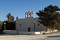
Church on Comino

Police station
Comino vegetation

Former quarantine station

Inner part of the former cemetery


literature
- Heinz Gstrein : Malta, with Gozo and Comino. Herder, Freiburg 1992, ISBN 978-3-7839-0554-0 (2nd edition)
- Hans E. Latzke: DuMont travel paperback Malta with Gozo and Comino . 2004, ISBN 3-7701-5972-1 .
- Werner Lips: Malta, Gozo, Comino . 1999, ISBN 3-89416-659-2 .
Web links
- interactive map of Malta, Gozo and Comino
- Comino photo gallery on Malta.co.uk
- detailed data and description of the island of Comino
- Comino on unitedcominoferries.com on May 2, 2015
Footnotes
- ↑ Victoria Mallia-Milanes. In Search of Vittorio Cassar. A documentary approach . In: Melita Historica , published by the Malta Historical Society, Vol. 9 (1984), pp. 247-269, here p. 260.
Comino | Cominotto | Filfla | Filfoletta | Fungus Rock | Gozo | Malta | Saint Paul's Islands