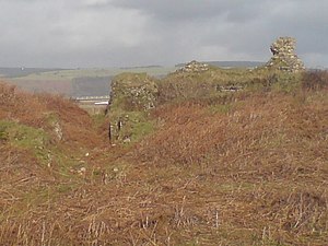
Kenfig Castle
| Kenfig Castle | ||
|---|---|---|
|
The ruins of Kenfig Castle |
||
| Alternative name (s): | Castell Cynffig | |
| Conservation status: | ruin | |
| Geographical location | 51 ° 31 '47.6 " N , 3 ° 43' 46.3" W | |
|
|
||
Kenfig Castle ( Welsh Castell Cynffig ) is a ruined castle in Wales . The ruin, protected as a Scheduled Monument , is located 10 km west of Bridgend in the Kenfig Burrows on the south bank of the River Kenfig.
history
Around 1140 Robert , Earl of Gloucester, and Lord of Glamorgan erected a moth on the Kenfig River. Due to a steep range of hills north of the river, the Romans had already laid their main road to western Wales at this point close to the coast, and the creation of a port at the mouth of the river soon created a settlement with a port south of the castle. St James Church was built between 1151 and 1154, and Kenfig became an important commercial and administrative center in the south of the Glamorgan rule, which is why it was attacked by Welsh insurgents at least nine times in the 12th and 13th centuries. The first attack came on January 13, 1167 by Morgan ap Caradog , the Welsh Lord of Afan , during whom the settlement was sacked. Another attack came after the death of the Norman Lord William FitzRobert in 1183 or 1184, in which the castle and the fortifications of the settlement raised to the borough were damaged. To strengthen it, a stone tower was built in the castle in 1185, using stones from ancient buildings from the Roman era. Two more attacks were made around 1228 and 1243 by the Welsh Lord of Meisgyn, Hywel ap Maredudd . Morgan Gam , the Lord of Afan, was able to conquer the city in 1232 and the castle up to the Keep . In 1257 Llywelyn ap Gruffydd attacked Kenfig. During the Welsh Revolt of 1294 , Morgan ap Maredudd captured the city in 1295 and destroyed parts of the castle. In 1316 the castle was destroyed during the Llywelyn Bren rebellion , and the castle was attacked again during the Despenser War of 1321 against Hugh le Despenser . However, not these multiple attacks and destruction brought the end of the castle and the settlement, but as with Pennard Castle on the Gower Peninsula , the increasing siltation around 1400 led to the castle being abandoned . Instead of the borough of Kenfig, the settlement of Pyle was built about 2.4 km east .
In 1924 the Aberafon and Margam Historical Society carried out the first excavations of the castle.
investment
The ruin of the heavily damaged complex consists of the remains of the free-standing, square keep and the remains of the foundations of other buildings southwest of the tower. The small inner castle had a diameter of about 37 m and was surrounded by a curtain wall and a deep moat that was flooded by the Kenfig River. The living hall was in the outer bailey south of the inner bailey . The spacious outer bailey was secured by ramparts and moats and later merged into the settlement. The ruins are now between the sand dunes of the 66 hectare Kenfig National Nature Reserve, but are freely accessible.
literature
- Royal Commission on the Ancient and Historical Monuments of Wales: An Inventory of the Ancient Monuments in Glamorgan , Vol. III - Part I: The early castles. RCAHMW, 1991, ISBN 978-0-11-300035-7 , pp. 314-326
- Elisabeth Whittle: Glamorgan and Gwent. HMSO, London 1992. ISBN 0-11-701221-1 , p. 194
Web links
- Kenfig: the complete history
- The Kenfig Society: Kenfig Castle - A Short History Of The Castle
- Castles of Wales: Kenfig Castle
Individual evidence
- ↑ Ancient Monuments: Kenfig Castle & Medieval Town. Retrieved December 28, 2013 .
- ↑ An Inventory of the Ancient Monuments in Glamorgan , Vol. III - Part I: The early castles. RCAHMW, 1991, ISBN 978-0-11-300035-7 , p. 316
- ↑ Royal Commission on the Ancient and Historical Monuments of Wales: An Inventory of the Ancient Monuments in Glamorgan : III - Part Ib: Medieval Secular Monuments - The Later Castles from 1217 to the present, HMSO, London 2000, ISBN 978-1-871184 -22-8 , p. 4
- ^ Adrian Pettifer: Welsh Castles. A Guide by Counties . Boydell, Woodbridge 2000, ISBN 978-0-85115-778-8 , p. 96
- ^ Bridgend County Borough Council: Kenfig National Nature Reserve. (No longer available online.) Archived from the original on September 4, 2012 ; Retrieved December 28, 2013 .


