Kepa (Kem)
|
Kepa Ке́па, Кеппа, Талвиёки, Тальвийоки (Talwijoki) |
||
|
|
||
| Data | ||
| Water code | RU : 02020000912102000004331 | |
| location | Republic of Karelia ( Russia ) | |
| River system | Kem | |
| Drain over | Kem → White Sea | |
| origin | Lake Tajawijarwi 65 ° 18 ′ 31 ″ N , 31 ° 34 ′ 57 ″ E |
|
| Source height | 188 m | |
| muzzle | in the Kem coordinates: 64 ° 48 ′ 30 " N , 32 ° 20 ′ 49" E 64 ° 48 ′ 30 " N , 32 ° 20 ′ 49" E |
|
| Mouth height | 87 m | |
| Height difference | 101 m | |
| Bottom slope | 0.66 ‰ | |
| length | 154 km | |
| Catchment area | 1640 km² | |
| Communities | Kepa | |
|
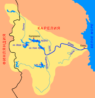
Course of the Kepa (Ке́па) in the catchment area of the Kem |
||
The Kepa ( Russian Ке́па, Кеппа, Талвиёки, Тальвийоки (Talwijoki)) is a left tributary of the Kem in the Republic of Karelia in northwestern Russia .
It has its origins in Lake Tajawijarwi (Таявиярви) in Kalewala Rajon . From there it flows in a south-easterly direction. It flows through several smaller lakes. It finally empties into the lake Kuljanjarwi ( Кулянярви ) through which the Kem flows . The Kepa has a length of 154 km. It drains an area of 1640 km². It flows through a sparsely inhabited region of Karelia. The only settlement on the river is the place of the same name Kepa . The river is ice-free between the end of April and November.
