Kermelbach
| Kermelbach | ||
|
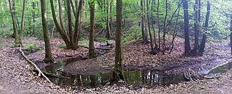
The Kermelbach near Witten |
||
| Data | ||
| Water code | DE : 27691742 | |
| location | Germany | |
| River system | Dysentery | |
| Drain over | Borbach → Ruhr → Rhine → North Sea | |
| source | at Herdecke -Appelsiepen 51 ° 25 '21 " N , 7 ° 23' 56" O |
|
| Source height | approx. 214 m above sea level NHN | |
| muzzle | in Witten -Borbach in den Borbach Coordinates: 51 ° 25 ′ 40 " N , 7 ° 22 ′ 33" E 51 ° 25 ′ 40 " N , 7 ° 22 ′ 33" E |
|
| Mouth height | approx. 140 m | |
| Height difference | approx. 74 m | |
| Bottom slope | approx. 28 ‰ | |
| length | approx. 2.6 km | |
| Catchment area | 1.924 km² | |
| Discharge A Eo : 1.924 km² at the mouth |
MNQ MQ Mq |
2.79 l / s 22.33 l / s 11.6 l / (s km²) |
| Navigable | No | |
The Kermelbach is about two and a half kilometers long flowing water in the area of the towns of Herdecke and Witten in the North Rhine-Westphalia Ennepe-Ruhr district . It is a south-east and left tributary of the Borbach .
geography
course
The Kermelbach has its headwaters in Appelsiepen, near the Gut Kermelbach, Straße Im Bruch , north of Westende, Herdecke . It rises at an altitude of about 214 m above sea level. NHN .
The stream flows underground verdolt below a riding place, will appear from a tube again on the surface and then runs in a westerly direction, slightly curved and strong sunk in a Muldentalhalle first through grassland, then through wasteland . It is fed by several small tributaries on its left side.
He now enters the Kermelbachtal nature reserve and shortly afterwards passes the municipal boundary from Herdecke to Witten. It then flows through the nature reserve in a north-northwest direction and finally flows northeast of the Große Borbach road at an altitude of about 140 m above sea level. NHN . in from the left into the Borbach approaching from the east .
The 2.6 km long course of the Kermelbach ends about 74 meters below its source, so it has a mean bed gradient of about 28 ‰.
Catchment area
The 1.924 km² catchment area of the Kermelbach is drained through it via the Borbach, the Ruhr and the Rhine to the North Sea.
It borders
- in the east to the catchment area of the Kirchender Bach , which drains over the Herdecker Bach into the Ruhr
- and in the south to that of the Ruhr tributary Enderbach .
The catchment area in the area of the upper reaches is mainly used as arable land and on the lower reaches it is mostly forested.
nature and environment
The Kermelbach is a near-natural meandering brook with flat and steep banks (partly rock) and local gravel banks. In the Herdecke area, the brook is considered to be one of the most affected brooks due to its extensive piping and backfilling.
Individual evidence
- ↑ Topographical Information Management, Cologne District Government, Department GEObasis NRW ( Notes )
- ↑ a b c Specialized information system ELWAS, Ministry for Climate Protection, Environment, Agriculture, Nature and Consumer Protection NRW ( notes )
- ↑ Nature reserves and the Eifel National Park in North Rhine-Westphalia - specialist information - area lists - nature reserves as a whole - NSG Kermelbach. Retrieved May 8, 2020 .
- ↑ Concept for the near-natural development of flowing waters in Herdecke , explanatory report, environmental department of the city of Herdecke, April 2003
