
Keşli
Coordinates: 36 ° 27 ′ 41.4 ″ N , 34 ° 4 ′ 30.2 ″ E


Keşli , also Keşlik , is the Turkish name for a building complex from the late Roman - early Byzantine period in Rough Cilicia in southern Turkey .
location
The place is located in the area of the Narlıkuyu hamlet Hasanaliler in the district of Silifke in the Turkish province of Mersin . From the coastal town of Narlıkuyu, a road leads past the Koryk Grottoes (Cennet ve Cehennem) through Hasanaliler into the mountainous hinterland to Uzuncaburç , the old Olba and Diokaisareia . The building is located about one kilometer west of the center of Hasanaliler with the early Byzantine church . From there it can be reached via Ören Sk. Or Keşlik Sk .
description
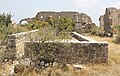
The complex is oriented approximately north-south, almost square and has dimensions of 47 × 48 meters without the corner risalite . The surrounding walls are closed on all sides, on the east side is the entrance with arch and gate hall. This side has two corner projections. The remains of at least 26 mostly rectangular rooms of roughly the same size can be seen along the outer walls. There was probably an upper floor above. Especially on the north wall, which has been preserved up to the original height, there are still holes in the bars on which the floors of the upper storey rested. The windows on both floors can also be seen. On the south side remains of belt arches can still be seen, through which the rooms were divided. Around the center of the courtyard is a vaulted cistern with a straight roof. A little north of it are the remains of the apse of a small chapel. To the west outside the structure, Chamosorien and an oil press can be seen in the area.
The Turkish art historian Semavi Eyice , who visited the building in the 1980s, interpreted Keşli as a castron . However, since pronounced bastions , as they are characteristic of military installations from the 4th to 6th centuries, are missing, as is a more secure gate, Friedrich Hild and Hansgerd Hellenkemper contradict this interpretation. In their opinion, the location away from the major highways speaks against the military character of the site. They consider the complex to be an agricultural property, as evidenced by the risalit façade typical of Roman villas . Since there are no stately living spaces to be seen, they suggest an estate run by an administrator.
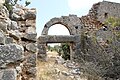
Gate from the inside

Room in the northwest corner

North wall with beam holes
cistern


literature
- Semavi Eyice: Ricerche e scoperte nella regione di Silifke nella Turchia meridionale In: Milion 1 - Studi e ricerche d'arte Bizantina (Atti della Giornata di Studio) . Rome 1986 pp. 22, 25
- Friedrich Hild, Hansgerd Hellenkemper: Kilikien and Isaurien. Tabula Imperii Byzantini Volume 5. Verlag der Österreichischen Akademie der Wissenschaften, Vienna 1990, ISBN 3-7001-1811-2 , p. 299
Web links
annotation
- ↑ The dimensions are given according to Eyice p. 25. Hild / Hellenkemper give the dimensions 47 × 58 meters, which is probably a typo according to the drawing on Eyice panel X as well as from the top view on GoogleEarth.