Kick-'em-Jenny
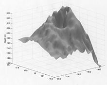
Kick-'em-Jenny, also known as Kick'em Jenny, is an active submarine volcano or deep-sea mountain at the bottom of the Caribbean Sea 8 km north of the island of Grenada and 8 km west of Ronde Island in the Grenadines .
Kick-'em-Jenny rises 1,300 m above the sea floor on the steep inner western slope of the ridge of the Lesser Antilles . The North American Plate is subject to subduction under the Caribbean Plate east of this ridge and under the volcanic arches of the Lesser Antilles.
activity
The first report on the volcano appeared in 1939, although it must have erupted many times before. On 23/24 In July 1939, an eruption broke through the sea surface and sent a cloud of steam and dust 275 m high into the air. It produced a series of tsunamis that were about 2 m high when they reached the north coast of Grenada and the southern Grenadines. In 2003 the summit reached a height of 180 m below the sea surface. It is believed that this has been the case since the 1960s.
The volcano erupted twelve times between 1939 and December 4, 2001. After that, the last eruption occurred from July 22nd to 28th, 2015. There have been signs of increased seismic activity since July 11th, 2015. On July 23rd, a tremor was so strong that the authorities issued an orange alert, the second highest ever.
None of the eruptions reached the strength of 1939, they were mostly detected by seismic recording devices. The larger eruptions could also be heard underwater or on land nearby as a deep rumbling sound.
In 2003, an underwater expedition discovered a crater with active fumaroles that secrete cold and hot gas bubbles. Samples of fresh olive basalt were collected. An arcuate collapse appeared on the western flank of the ridge and was apparently the cause of a submarine landslide that stretched 15 km westward toward the Grenada Basin up the slope.
etymology
The volcano was unknown before 1939, although "Kick'em Jenny" appeared on previous maps either as the name of a small island now called Diamond Rock (or Île Diamante), or as the name of the strait between Grenada and Ronde Island ( also Île de Ronde). The name itself may have a reference to the waters, which are sometimes extremely rough.
Other adjacent volcanoes
"Kick'em Jenny" is adjacent to another small underwater volcano "Kick'em Jack", which even has a somma , as well as other smaller cones.
See also
Individual evidence
- ↑ Kick em 'Jenny Home . The University of West Indies-Seismic Center. Retrieved October 16, 2009.
- ↑ Lopes, Rosaly MC (2005), The volcano adventure guide , Cambridge University Press , Illustrated ed. P. 11. ISBN 0521554535
- ↑ a b c Lyn Topinka: DESCRIPTION: Kick 'Em Jenny Volcano, West Indies . United States Geological Service . December 12, 2001. Retrieved October 16, 2009.
- ↑ http://volcano.si.edu/showreport.cfm?doi=GVP.WVAR20150722-360160 Report of the Smithonian Institute
- ↑ Changed Alert Level at Kick 'em Jenny Submarine Volcano . Retrieved July 24, 2015.
- ↑ Steve Mattox: Kick-'em-Jenny, West Indies . University of Oregon . April 5, 2002. Archived from the original on February 4, 2009. Info: The archive link was inserted automatically and has not yet been checked. Please check the original and archive link according to the instructions and then remove this notice. Retrieved October 16, 2009.
- ^ Profile of the volcano on the Smithsonian Institute register
Coordinates: 12 ° 18 ′ N , 61 ° 38 ′ W

