
Kickerlingsberg
| Kickerlingsberg | |
|---|---|
|
|
|
 |
|
| Kickerlingsberg to the southeast | |
| Basic data | |
| place | Leipzig |
| District | Center-Northwest / Center-North / Gohlis-South |
| Created | 1904 |
| Connecting roads | Nordplatz, Poetenweg |
| Cross streets | Karl-Rothe-Strasse, Springer-, Trufanow-, Ehrenstein- and Prellerstrasse |
| use | |
| User groups | Pedestrian traffic , bicycle traffic , car traffic |
| Technical specifications | |
| Street length | 820 m |
Kickerlingsberg is the name of a street in the northern suburb of Leipzig .
course
The Kickerlingsberg runs with slight bends over a length of 820 meters from southeast to northwest from the north square to the Gohliser Schlösschen on Poetenweg. The street forms the border between the districts center-northwest and center-north or Gohlis-south. It marks the edge of the terrain sloping southwest towards the Parthenaue .
history
The street name Kickerlingsberg, which is unique in Germany, goes back to an old field name. In Grimm's dictionary , kickerlings are referred to as a type of small biting mosquito or flies, so that the name from the vicinity of the Parthe (formerly the Pleißemühlgraben ) and the elevation of the area above the floodplain appears plausible.
In the 19th century the area was a military parade ground, from 1880 for the Saxon 10th Infantry Regiment No. 134 , which had its barracks north of it. The Pestalozzistift, an institution for difficult-to-educate boys, was also located here.
At the beginning of the 20th century, the site was parceled out and the wealthy Leipzig bourgeoisie began building a residential area, the location of which was very popular because of its proximity to the Rosental valley, which is located over the Pleißemühlgraben . While side streets have been renamed several times, the Kickerlingsberg has kept its name since 1904.
From 1926 until its destruction in 1943, the Leipzig Planetarium stood at the southeastern beginning of the Kickerlingsberg . After the invasion of the Red Army in 1945, a large part of the buildings in the quarter was confiscated by the Soviet military administration to accommodate military staff . After the fall of the Wall (1989/1990), all houses on Kickerlingsberg were renovated.
Development
Villa at the corner of Springerstrasse

Old and new at the corner of Trufanowstrasse


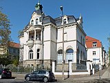
From the Nordplatz to Ehrensteinstrasse, the right side of the Kickerlingsberg is made up of city villas from the early days of the district, all of which are listed. The only exception is a modern new building on the corner of Trufanowstrasse. A small green area then follows up to Prellerstraße.
On the left, the area of the zoo, especially the elephant enclosure, extends from Nordplatz to Karl-Rothe-Straße. This is followed by the allotment garden association Nordvorstadt from 1880, the third oldest in Leipzig, as far as Prellerstraße, lower down in the strip up to the Parthe. At the beginning there is still the old, listed clubhouse from 1898 with a protruding glare framework on the upper floor. In a roundabout opposite Ehrensteinstrasse, from which two stairs lead to the gardens, there is a red beech from 1900.
literature
- Gina Klank, Gernoth Griebsch: Lexicon of Leipzig street names . Ed .: City Archives Leipzig. 1st edition. Verlag im Wissenschaftszentrum Leipzig, Leipzig 1995, ISBN 3-930433-09-5 , p. 121 .
Web links
- Kickerlingsberg in Leipzig. In: Streets in DE. Retrieved April 21, 2019 .
- Directory of Leipzig street names. (PDF) In: Website of the City of Leipzig. Retrieved April 21, 2019 .
Individual evidence
- ^ Kickerlingsberg in Leipzig. In: Streets in DE. Retrieved April 21, 2019 .
- ↑ Kickerling. - Section: 6). In: Jacob Grimm , Wilhelm Grimm (Hrsg.): German dictionary . tape 11 : K - (V). S. Hirzel, Leipzig 1873 ( woerterbuchnetz.de ).
- ↑ City map Leipzig 1890. Retrieved on April 21, 2019 .
- ↑ To the Pestalozzistift . In: The Gazebo . Issue 16, 1888, pp. 274, 275 ( full text [ Wikisource ]).
- ^ Peter Schwarz: The millennial Leipzig . From the beginning of the 20th century to the present. 1st edition. tape 3 . Pro Leipzig, Leipzig 2015, ISBN 978-3-945027-13-4 , pp. 209 .
- ↑ Gardener in the north suburb. In: Insider tip Leipzig. Retrieved April 22, 2019 .
- ↑ Official city map. In: Website of the city of Leipzig. Retrieved April 22, 2019 . (Call layer street trees)
Coordinates: 51 ° 21 ′ 12 ″ N , 12 ° 22 ′ 5 ″ E