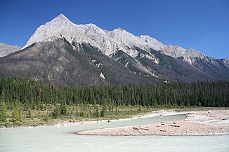
Kicking Horse River
| Kicking Horse River | ||
|
Kicking Horse River |
||
| Data | ||
| location | Columbia-Shuswap Regional District in British Columbia (Canada) | |
| River system | Columbia River | |
| Drain over | Columbia River → Pacific Ocean | |
| source | Wapta Lake 51 ° 26 ′ 23 " N , 116 ° 21 ′ 2" W. |
|
| muzzle | in the Columbia River at Golden Coordinates: 51 ° 18 '25 " N , 116 ° 59' 16" W 51 ° 18 '25 " N , 116 ° 59' 16" W.
|
|
| length | approx. 80 km | |
| Drain at the Golden gauge |
MNQ MQ MHQ |
2.25 m³ / s 40.9 m³ / s 402 m³ / s |
| Right tributaries | Yoho River , Amiskwi River , Otterhead River | |
| Small towns | Golden | |
| Communities | Field | |
| Canadian Heritage River | ||
|
Kicking Horse River at the Park Bridge rest area near Golden. Trans Canada Highway left, CPR Mainline right |
||
|
Kicking Horse River at the base of Chancellor Peak |
||
|
Footbridge over the Kicking Horse River in Golden |
||
The Kicking Horse River is a right tributary of the Columbia River in the Canadian Rockies in the southeast of the Canadian province of British Columbia .
The river has the status of a Canadian Heritage River .
The river got its name in 1858 when James Hector , a participant in the Palliser Expedition , was kicked in the chest by his horse on the river. Hector survived and named the river and mountain pass after this event. The Kicking Horse Pass , which connects the valley of the river with that of the Bow River , was the mountain route later selected by the Canadian Pacific Railway when it was built in the 1880s. The so-called Big Hill of the railway and the subsequent spiral tunnels are located in the Kicking Horse Valley . They were necessary because of the steep descent of the river valley.
River course
The Kicking Horse River has its origin in Wapta Lake , from where it flows in a southwesterly direction. It takes up the Yoho River above Field . The river continues to flow southwest until it reaches Wapta Falls , where it changes its flow direction abruptly and turns northwest until it joins the Columbia River at Golden .
water falls
The river has three waterfalls along its stretch of flow. The first is the Kicking Horse Cascade , a long talus waterfall located on the first highway crossing below Wapta Lake. The second waterfall is the Natural Bridge Falls at Field. The last and largest waterfall is the approximately 30 m (100 ft) high and approximately 150 m (500 ft) wide Wapta Falls , one of the largest waterfalls in Canada in terms of volume and width.
Tributaries
- Sherbrooke Creek
- Yoho River
- Emerald River
- Amiskwi River
- Otterhead River
- Ottertail River
- Porcupine Creek
- Beaverfoot River
- Glenogle Creek
Web links
- Kicking Horse River ( English, French ) In: The Canadian Encyclopedia .
- Kicking Horse River . In: BC Geographical Names (English)
Individual evidence
- ↑ a b Kicking Horse River . Canadian Geographical Names Database, Ottawa - Government of British Columbia , accessed July 8, 2012 .


