Kiev Sea
| Kiev Sea | |||||||
|---|---|---|---|---|---|---|---|
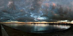
| The Kiev Sea in March 2017 | |||||||
|
|||||||
| Coordinates | 50 ° 36 ′ 0 ″ N , 30 ° 30 ′ 0 ″ E | ||||||
| Data on the structure | |||||||
| Construction time: | - 1964 | ||||||
| Height of the barrier structure : | 38 m | ||||||
| Building volume: | 45.700 million m³ | ||||||
| Crown length: | 42,817 m | ||||||
| Data on the reservoir | |||||||
| Water surface | 922 km² | ||||||
| Storage space | 3730 million m³ | ||||||
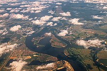
| Landsat image of the Kiev Sea | |||||||
| Map of the Kiev Sea (reservoir) | |||||||
Kiev Sea (Ukrainian Київське водосховище / Kyjiwske wodoschowyschtsche ; Russian Киевское водохранилище / Kiewskoje wodochranilischtsche ) is the name for a reservoir at Kiev. It begins 20 km north of Kiev and has an area of 922 km². In the north it is fed by the Pripyat and Dnepr rivers and extends as far as the Belarusian border.
The reservoir was created in the 1960s under Nikita Sergejewitsch Khrushchev . The Dnepr is dammed up to a width of 20 km here. The difference in altitude is used in a large hydroelectric power station to generate electricity. It was built as the last of the six reservoirs .
The barrier structure is a 41 km long dam, which at the time of its construction was the longest dam on earth. Today in America there are two longer ones and two more longer ones that are still under construction, so that the Kiev dam is now in sixth place (see list of dams in the world ).
The Kiev Sea has some steep banks with deep cuts in the landscape, which run across the river.
There are no larger towns on the lake, only smaller towns such as Vyshhorod , Nowi Petrivtsi , Stari Petrivtsi , Lyutisch and other villages.
Individual evidence
See also
- Reservoirs in Ukraine
- List of the largest dams on earth
- List of the largest reservoirs on earth
- List of the largest hydroelectric plants in the world
- List of dams in the world


