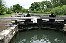
King's Lock
King's Lock is a lock on the River Thames in England . The lock is north of Oxford in Oxfordshire on the south side of the river. The lock was one of the last in the course of the Thames to be built by the Thames Conservancy to replace a flood lock.
There is a large island at the lock. This is where the Wolvercote Mill Stream begins , which leads to the Duke's Cut , which connects the Thames to the Oxford Canal . The Wolvercote Mill Stream flows back into the Thames below Godstow Lock . The weir is on the other side of the island. There is a small visitor center by the lock.
history
A weir has been recorded at the site of the lock since the 16th century. A lock was first proposed in 1817 but was never built. Another attempt to build it in 1845 was also unsuccessful. For a long time there were complaints about the water level at the weir and that the lock was not being serviced. Around 1872 a boat slide was built to guide smaller boats around the weir. The weir was renewed in 1885, but a lock was not built until 1928.
The river above the lock
A little upriver from the lock is the northernmost point of the Thames. Upstream, the Wolvercote Mill Stream is diverted from the river on the north side and the Seacourt Stream separates from the river on the south side . The River Evenlode and the Cassington Cut , an arm of the River Evenlode, flow on the north side. The Wharf Stream joins the river just before Eynsham Lock .
The Thames Path runs on the south side of the river to Eynsham Lock.
See also
Individual evidence
- ^ Fred S. Thacker: The Thames Highway. Volume II: Locks and Weirs. 1920 (New edition: David & Charles, Newton Abbot 1968, ISBN 0-7153-4233-9 .)
Coordinates: 51 ° 47'20.6 " N , 1 ° 18'24.9" W.
