Kirchhof (Kötzschenbroda)
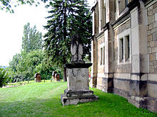
The churchyard around today's Friedenskirche in Kötzschenbroda is the abandoned cemetery of the oldest church in the Lößnitz communities . The cemetery stands today along with the church under monument protection .
history
The history of the churchyard as originally the only burial place of the Parish Kötzschenbroda can be traced back to the year 1273, when the predecessor of today's church was first mentioned in a document. After the church was destroyed several times by fires and war, as well as reconstruction, the churchyard in its current form was laid out in 1602, surrounded by a high sandstone wall and with decorative grills between pillars.
Before 1566 the parish was in the second burial site Prince Hain created a plague cemetery, which remained even after the epidemics in use and as a cemetery , later than age cemetery was designated. From the end of the 17th century, the churchyard became the main burial place. In 1723 the area of the churchyard was expanded again. In 1884/1885 for the reconstruction of the Friedenskirche it was officially closed as a burial place. As the only later exception, the art historian Richard Steche was buried on January 6, 1893 in the presence of an illustrious mourners in the churchyard.
Prescher's grave slab, which was placed between the two sawed-apart figures of Chronos and the mourners around 1900 , was removed from there in the first half of the 20th century and placed in the entrance area of the church. The group of figures from Chronos was put back together and taken to the Hoflößnitz . After the restoration in 2004, the group of figures came back to the Kötzschenbrodaer Kirchhof.
Tombs
Tombs described in terms of monument preservation
- Chronos and the mourner
- Richard Steche (1837–1893), architect, art historian and preservationist, founder of the Saxon inventory
- Charles Francois Mouzon († 1845), son of Johann Joseph Mouzon, cellar master of the factory for sparkling wines (later the Bussard Sektkellerei)
- Dorothea Helena († 1653) (baroque)
- Adelheid Andree, b. Solbrig (1807–1864), wife of the consul Karl Andree
- Johann Traugott Große (1800–1861), master mason and Johanna Sophie Große (1801–1875), wife
- Johann Christian Vetters († 1844), owner of a farm
- Gustav Robert Große (1847-1858), son of Johann Traugott Große (historicist)
- Eduard Thomann (1786–1848), merchant and vineyard owner
- Family Karl August Seifert (1799–1843), owners of the Oberschänke (baroque)
- Tomb with illegible writing (classicistic)
- Augustin Prescher (1593–1675), pastor (grave slab in the entrance of the church)
7 gravestones in the Kötzschenbroda churchyard on the back wall of the Oberschänke (one covered by the tree)
More buried there
- Henning August von Bredow (1774–1832), vineyard owner
literature
- Frank Andert (Red.): Radebeul City Lexicon . Historical manual for the Loessnitz . Published by the Radebeul City Archives. 2nd, slightly changed edition. City archive, Radebeul 2006, ISBN 3-938460-05-9 .
- Volker Helas (arrangement): City of Radebeul . Ed .: State Office for Monument Preservation Saxony, Large District Town Radebeul (= Monument Topography Federal Republic of Germany . Monuments in Saxony ). SAX-Verlag, Beucha 2007, ISBN 978-3-86729-004-3 .
- Gudrun Taubert; H.-G. Staudte: Art in Public Space II. Gravestones . In: Association for Monument Preservation and New Building Radebeul (ed.): Contributions to the urban culture of the city of Radebeul . Radebeul 2005.
Web links
Individual evidence
- ^ Large district town of Radebeul (ed.): Directory of the cultural monuments of the town of Radebeul . Radebeul May 24, 2012, p. 2 (Last list of monuments published by the city of Radebeul. The Lower Monument Protection Authority, which has been part of the Meißen district since 2012, has not yet published a list of monuments for Radebeul.).
Coordinates: 51 ° 6 ′ 14.4 " N , 13 ° 38 ′ 3.2" E


