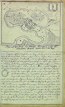
Kirumpää
Coordinates: 57 ° 51 ′ 44.3 " N , 26 ° 59 ′ 29.6" E
Kirumpää (German: Kirrumpäh ) is a village in the rural municipality of Võru , Võru County in southeast Estonia .
Kirumpäh Bishop's Castle
history
A castle was strategically located on a hill above the river Võhandu (Woo) , which controlled an important road ( Dorpat - Pleskau ) and a river crossing. This castle was first mentioned in 1322 when it was destroyed by Grand Duke Gediminas of Lithuania . The castle was probably founded by the bishops of Dorpat in the second half of the 13th century to protect the eastern border of the diocese. During the Livonian War (1558), the site was occupied, sacked and badly damaged by Russian troops, but continued to be used until it and the site were destroyed during the Great Northern War at the beginning of the 18th century. When the town of Võru was built in 1784, the castle served the residents as a quarry.

buildings
Originally a thick-walled 14 × 10 m tower castle stood here . This formed the northeast corner of the later approximately square 42 × 45 m three-winged complex. First, the tower was built around a castle chapel in the west and later, in the 15th century, with two more wings with small rooms in the south. A round tower was in the south-west corner. The access was from the west via a trapezoidal walled forecourt with a bastion in front.
Today only earthworks and rudimentary wall remains made of field stones (granite) and bricks bear witness to the castle.
literature
- Baltic historical local dictionary. Part 1: Estonia (including Northern Livonia). Started by Hans Feldmann . Published by Heinz von zur Mühlen . Edited by Gertrud Westermann . Böhlau, Köln / Wien 1985 (= sources and studies on Baltic history. Volume 8/1), ISBN 3-412-07183-8 , p. 231.
Web links
- Entry 14142 in the Estonian inventory of monuments
- Homepage of the Estonian Tourist Association
- Riksarkivet (Swedish Imperial Archives): Geometric floor plan of the old Kiriumpäh Castle and the bay beach measured. ( Memento of November 28, 2012 in the web archive archive.today ) - Plan of the Episcopal Castle and its surroundings, 17th century
- Riksarkivet (Swedish Imperial Archives): Kirienpais. (Kiriumpä) ( Memento from November 28, 2012 in the web archive archive.today ) - Plan of the bishop's castle , 17th century


