Klausmühlebach
| Klausmühlebach | ||
|
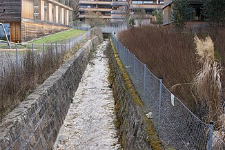
The Klausmühlebach just before it flows into Lake Constance. |
||
| Data | ||
| Water code | AT : 8106 | |
| location | Austria | |
| River system | Rhine | |
| Drain over | Lake Constance → Rhine → North Sea | |
| source | at Pfänder 47 ° 30 ′ 41 ″ N , 9 ° 46 ′ 54 ″ E |
|
| Source height | 989 m above sea level A. | |
| muzzle | in Lochau -Tannenbach in the Bodensee Coordinates: 47 ° 30 '43 " N , 9 ° 45' 7" E 47 ° 30 '43 " N , 9 ° 45' 7" E |
|
| Mouth height | 395 m above sea level A. | |
| Height difference | 594 m | |
| Bottom slope | 23% | |
| length | 2.6 km | |
The Klausmühlebach (also short: Klausbach ) is a 2.62 km long stream in the municipality of Lochau ( Vorarlberg , Austria ).
Surname
The name of the stream comes from the Klausmühle , which was located here for centuries and which was demolished in 1978 . The Klausmühle, on the other hand, takes its name from the nearby geographical narrow point ( Klause ), where there were several military barriers to protect Vorarlberg from the incursions of troops from the Swabian , Bavarian and Württemberg regions.
geography
course
The Klausmühlebach rises at an altitude of 989 m above sea level. A. on the Pfänder below the Ober-Flühlenauf plot .
The brook first flows from east to west and in the upper half the brook then makes a large curve to the north.
It finally flows into the Lochau district of Tannenbach at an altitude of 395 m above sea level. A. directly in Lake Constance .
Its 2.6 km long run ends about 594 meters below its source, so it has an average bed gradient of 23%.
Tributaries
The Klausmühlebach has several tributaries. For water kilometers (GwKm) 1.81 and 1.558 a nameless stream from the left. At GwKm 1.31 the Lohornbach and the Obere Riesgraben from the right. At GwKm 0.935 the Untere Riesgraben joins from the right and at GwKm 0.785 the Altreutegraben joins from the right. From GwKm 0.34, the stream is heavily regulated up to its confluence with Lake Constance and wedged into concrete / quarry stone walls, far from nature.
At GwKm 1.258 (west tube) and 1.451 (east tube) the Rheintal / Walgau motorway A14 crosses under the Klausmühlebach in the Pfänder tunnel .
History and economic use
In a document dated July 20, 1463, the Vogt of both parts of the Bregenz rule decided on mills and water rights on Klausmühlebach. The water power of the stream was already in intensive use by several users in the Middle Ages .
Trivia
About 31 meters north of Klausmühlebach is the St. Magdalena chapel . The Neue Schanze is located directly on Klausmühlebach, a few meters before the confluence with Lake Constance .
