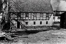
Klein-Liebenau
|
Klein-Liebenau b. Gottleuba
community Liebenau
Coordinates: 50 ° 47 ′ 7 ″ N , 13 ° 53 ′ 59 ″ E
|
||
|---|---|---|
| Height : | 527 m above sea level NN | |
| Residents : | 0 (1973) | |
|
Location of Klein-Liebenau b. Gottleuba in Saxony |
||
Klein-Liebenau b. Gottleuba or Kleinliebenau (zu Liebenau) is a district of the village of Liebenau . The district has been desolate since 1973 .
geology
The Klein-Liebenau corridor is located on the northeastern slope of the Osterzgebirge . The Gottleuba drains them in the valley in a northerly direction. It is geologically formed by the archaic gneiss formation with biotite gneiss of the Ore Mountains. The gneiss in this region is not geologically disturbed by other rocks ( porphyry , basalt , ore deposits, ...). It was also not opened up by rocks, quarries or mines. The weathering takes place in small bowls or scales and forms a good and deep weathered soil that can be used for agriculture.
The valley floor is covered by alluvial deposits ( Holocene ) with gravel and clay deposits. Due to the existing depressions (basement, old pond and ditches) and the regulation of the Gottleuba a swampy wet meadow has now formed here. The whole surface was reworked and cultivated by human hands.
geography
The Klein-Liebenau corridor is located on the German-Czech border in the upper Gottleubatal. The neighboring communities are Fürstenwalde , Liebenau and Oelsengrund (wüst). In the former local area the Falkenbach and the Nasenbach flow into the Gottleuba.
history
Around the year 1350 the hammer Klein-Liebenau and with it the place was mentioned for the first time. Klein-Liebenau consisted of an inn, which was later converted into a border station, an apartment building that served the customs officers and their families as a residential building (customs house) and a rural economy with a residential building, stables and a barn. The economy was in operation until it was razed in 1973.
literature
- C. Gäert, R. Beck: Explanations for the special geological map of the Kingdom of Saxony . Section Fürstenwalde-Graupen, K. Finance Ministry, Leipzig 1903.
- C. Gäert, R. Beck: Special geological map of the Kingdom of Saxony . Section Fürstenwalde-Graupen No. 120, K. Finance Ministry, Leipzig 1903.
- Annemarie u. Siegfried Fischer: Traces of old mills on the Gottleuba and its tributaries . Chronicle 2011, PDF 2011.


