Kleinbernsdorf (Münchenbernsdorf)
|
Kleinbernsdorf
City of Münchenbernsdorf
Coordinates: 50 ° 49 ′ 51 ″ N , 11 ° 56 ′ 20 ″ E
|
|
|---|---|
| Height : | 287 m |
| Residents : | 300 |
| Incorporation : | July 1, 1950 |
| Postal code : | 07589 |
| Area code : | 036604 |
|
Location of Kleinbernsdorf in Münchenbernsdorf
|
|
|
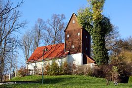
Village church
|
|
Kleinbernsdorf is a district of Münchenbernsdorf with 300 inhabitants in the Greiz district in Thuringia .
location
Kleinbernsdorf is located east of the city of Münchenbernsdorf on the state road 1078 coming from Großsaara and continuing to Lederhose to the federal highway 9 . The gentle valley with slopes is used for agriculture.
history
The first documentary mention took place on May 15, 1270. As early as 1922, Kleinbernsdorf was assigned to Münchenbernsdorf according to a Council of Ministers resolution. However, the settlement took place in 1925, but in 1950 the place finally came to Münchenbernsdorf. The church bells from the 14th century were renovated in 2001.
→ See also the village church of Kleinbernsdorf
Web links
Commons : Kleinbernsdorf - Collection of pictures, videos and audio files
Individual evidence
- ^ Wolfgang Kahl : First mention of Thuringian towns and villages. A manual. Rockstuhl Verlag, Bad Langensalza 2010, ISBN 978-3-86777-202-0 , p. 143
- ^ Kleinbernsdorf - district of Münchenbernsdorf. Archived from the original on December 19, 2012 ; accessed on June 6, 2017 .

