Klosterhöhe (Wertheim)
|
Klosterhöhe
City of Wertheim
Coordinates: 49 ° 43 ′ 31 ″ N , 9 ° 35 ′ 31 ″ E
|
|
|---|---|
|
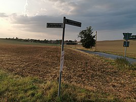
View of the scattered settlement Klosterhöhe from the intersection between the streets Klosterhöhe and Wassersteinchen
|
Monastery height is a scattered settlement on the streets Monastery height and Wassersteinchen on the boundaries of the Wertheimer village height field in the Main-Tauber-Kreis in Baden-Wuerttemberg .
geography
![]() Map with all coordinates of the individual farms of the scattered settlement Klosterhöhe: OSM
Map with all coordinates of the individual farms of the scattered settlement Klosterhöhe: OSM
Klosterhöhe is a scattered settlement on the streets Klosterhöhe ( ⊙ ) and Wassersteinchen ( ⊙ , ⊙ , ⊙ , ⊙ , ⊙ ) about 1.5 kilometers northwest of Höhefeld. Other surrounding places are Wagenbuch after about 500 meters in the east, Mittelhof after about 1.5 kilometers in the west and Klosterweg after about one kilometer in the northwest.
history
On the table sheet No. 6223 "Wertheim" from 1927 the place was still completely uninhabited. At the northwestern edge of the scattered settlement, a former Remmelhof was mentioned on the table sheet . The living space came to the city of Wertheim on January 1, 1975 as part of the formerly independent municipality of Höhefeld.
Cultural monuments
Cultural monuments in the vicinity of the residential area are recorded in the list of cultural monuments in Wertheim .
traffic
The place can be reached both from the direction of Höhefeld and from the direction of Bronnbach via the K 2882 . In the western part of the scattered settlement this is also known as Klosterhöhe . The other houses of the scattered settlement are on the branching off street Wassersteinchen .
Web links
- Klosterhöhe on the website www.leo-bw.de
- Measuring table sheet 6223 Wertheim from 1927 in the Deutsche Fotothek
Individual evidence
- ↑ a b Location information according to LEO-BW.de: Klosterhöhe . Online at www.leo-bw.de. Retrieved March 10, 2020.
- ↑ German Photo Library. In: deutschefotothek.de. Retrieved August 7, 2020 .
- ^ Federal Statistical Office (ed.): Historical municipality directory for the Federal Republic of Germany. Name, border and key number changes in municipalities, counties and administrative districts from May 27, 1970 to December 31, 1982 . W. Kohlhammer, Stuttgart / Mainz 1983, ISBN 3-17-003263-1 , p. 469 .

