
Knobs Flat
| Knobs Flat | ||
| Geographical location | ||
|
||
| Coordinates | 44 ° 59 ′ S , 168 ° 1 ′ E | |
| Region ISO | NZ-STL | |
| Country |
|
|
| region | Southland | |
| District | Southland District | |
| Ward | Te Anau Ward | |
| Residents | few | |
| height | 363 m | |
| Post Code | 9679 | |
| Telephone code | +64 (0) 3 | |
| Photography of the place | ||
 Access to the visitor center |
||

Knobs Flat is a small town in the Southland District of the Southland regionon the South Island of New Zealand .
Origin of name
The settlement was called Knobs Flat , because the former glacier's debris deposits formed "peculiar" mounds of earth in the valley.
geography
Knobs Flat is located about 53 km north-northeast of Te Anau in the valley of the western arm of the Eglinton River , on New Zealand State Highway 94 leading north to Milford Sound , which is also the only access to the settlement. West of the village rise up to 1854 m high Earl Mountains and east of the Livingstone Mountains . About 11 km northeast is Lake Gunn and it is 28 km to the Te Anau Downs , which is southwest on the east side of Lake Te Anau .
tourism
On State Higway 94 there is a visitor center with a room with information boards for the construction of Milford Road and the Homer Tunnel , which is 15 miles north of the settlement, and a toilet facility. In addition to overnight accommodation, the settlement only consists of a few scattered residential buildings.
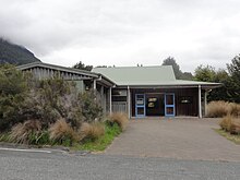
The visitor center
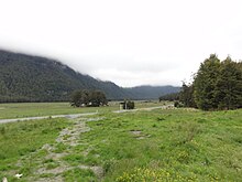
View over the SH94 to the opposite side of the valley


literature
- Helga Neubauer: Knobs Flat . In: The New Zealand Book . 1st edition. NZ Visitor Publications , Nelson 2003, ISBN 1-877339-00-8 , pp. 909 f .
Individual evidence
- ^ Neubauer: Knobs Flat . In: The New Zealand Book . 2003, p. 909 .
- ↑ Topo250 maps . Land Information New Zealand , accessed June 29, 2017 .