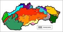
Košická kotlina

The Košická kotlina (German about Kaschauer Kessel ) is a basin located in eastern Slovakia , which geomorphologically belongs to the Loschontz-Kaschauer Depression ( Lučensko-košická zníženina ) and thus to the Inner Western Carpathians .
The boiler is in the west of the Slovak Ore Mountains and the Slovak Karst , in the north of the mountain countries Šarišská highlands and Ondavská highlands , east of the vrchy Slanské , in the southeast of the small mountain vrchy Zemplínske and to the south by gently rolling terrain of the hills Bodvianska pahorkatina / Cserehát on the Hungarian border.
The highest point of the basin is Diaľňa ( 384 m nm ). Important rivers are the Hornád , the Torysa and the Bodva and their tributary Ida . The two largest cities in Eastern Slovakia , Prešov and Košice, are located in the basin . Traffic routes run through the valley basin in both north-south (from Poland to Hungary) and west-east (to Ukraine) directions.