Kohout (North Bohemia)
| Kohout | ||
|---|---|---|
| height | 588.8 m nm | |
| location | Czech Republic | |
| Mountains | Central Bohemian Uplands | |
| Coordinates | 50 ° 42 '36 " N , 14 ° 18' 44" E | |
|
|
||
| Type | Kegelberg | |
| rock | basalt | |
| Development | Construction of the observation tower in 1908 | |
The Kohout ( German Krohberg , also Hahnbusch , 589 m) is a rather unmarked mountain in the northeast of the Bohemian Uplands near Benešov nad Ploučnicí .
Location and surroundings
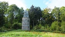
The Kohout rises 4 km south of the town of Benešov nad Ploučnicí ( Bensen ). Surrounding places in the south are the villages Blankartice ( Blankersdorf ) and Valkeřice ( Algersdorf ). The mountain, overgrown with beech forest, lies on a plateau that falls north of the Kohout near Františkov nad Ploučnicí ( Franzenthal-Ulgersdorf ) into the deeply cut valley of the Ploučnice ( Polzen ). There is an observation tower on the summit, which offers a view especially towards the Lusatian Mountains . Its tip is crowned by an iron rooster in keeping with the historical model.
history
The tower was built by the association of German tourists to plans by Anton Möller and on 16th August 1908 Kaiser marking the 60th anniversary of the reign of Franz Joseph I inaugurated. The former Kaiser-Franz-Josef-Turm is a 12 m high round tower made of stone walls. Inside the tower there is a stone staircase along the tower wall. On top of the brick tower is an approximately 4 m high iron construction with an inner spiral staircase, which is reminiscent of the tower on the Studenec ( Kaltenberg ) in its design .
The tower, which was extensively renovated in 2010, offers a view of the Lusatian Mountains to the east and north. The view in other directions is not possible, as the tower is dominated by the tops of the surrounding beeches , sycamores and ash trees .
Of the building that used to be next to the tower, only the foundation walls are visible today. The base of a monument donated by the "42nd Infantry Association North Bohemia" is also still recognizable.
Paths to the summit
The ascent to the mountain takes place from the blue- marked hiking trail that leads north from Valkeřice to Terezínské Údolí ( Theresienthal ) and Benešov, via a 600 m long branch. In continuation of this path there are several viewpoints in the Ploučnice valley, which is not possible from the top of the mountain.

