Tasiilaq (bay)
| Tasiilaq Kong Oscars Havn |
||
|---|---|---|
|
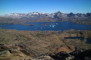
Bay and town of Tasiilaq from the southwest (Qaqqartivakajik) |
||
| Waters | Irmingersee | |
| Land mass | Ammassalik Island ( Greenland ) | |
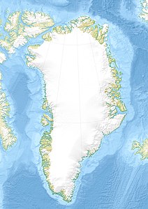
| Geographical location | 65 ° 37 '14 " N , 37 ° 36' 15" W | |
|
|
||
| width | Max. 4 km | |
| depth | approx. 8 km | |
| Greatest water depth | 211 m | |
| Islands | Fugleøerne | |
| Tributaries | Tributaries from local lakes and glaciers | |
The bay Tasiilaq ( Danish Kong Oscars Havn ) is a small bay in the south of the Ammassalik Island in southeastern Greenland . On its west bank is the city of the same name, the largest settlement on Greenland's east coast. The name Tasiilaq means "like a (calm) lake".
geography

The approximately 8 km long and up to 4 km wide fjord-like bay is located in the south of the Ammassalik Island at the mouth of the Ammassalik Fjord. Kong Oscars Havn is only about 750 m wide in the mouth area, which gives it the shape of a harbor basin. Both the Greenlandic and the Danish name (translated King Oskar's harbor ) refer to it. Conspicuous terrain points are the approximately 1.8 km long Aammaqqaaq peninsula in the north of the bay, the Fugleøerne archipelago ( 65 ° 37 ′ 46 ″ N , 37 ° 36 ′ 51 ″ W ) and a nameless larger island in the eastern part. The rocky coast is lined with some striking peaks, including the Qaqqartivakajik (Sømandsfjendet, 679 m ) southwest of Tasiilaq and the Qimmeertaajaliip Qaqqartivaa (Polhems Fjeld, 1015 m ) on the opposite bank. Several water-rich streams flow into the bay from the surrounding lakes, including the one from the Blomsterdalen ( Valley of Flowers ), which divides the town of Tasiilaq into two halves. Another tributary comes from Qorlortoq Sø, the largest lake on the island, which is at least partially fed by the Mittivakkat glacier . The stream overcomes the last steep step in a spectacular waterfall ( 65 ° 38 ′ 57 ″ N , 37 ° 37 ′ 33 ″ W ), which is often passed on trekking tours .
history
In 1884 Gustav Frederik Holm was the first European to reach the Inuit settlement Tasiilaq with his women's boat expedition , which was given the Danish name Ammassalik . Alfred Gabriel Nathorst named the bay in 1898/99 after Oskar II , King of Sweden and Norway since 1872 . The monarch sponsored some polar expeditions of his time, including the second Greenland trip by Adolf Erik Nordenskiöld (1883). The bay shares this name with the much larger Kong Oscar Fjord between the Zackenberg research station and Ittoqqortoormiit .
Literature and maps
- Hasse Højmark Andersen, Jette Christensen, Walther Jessen Christensen, Maiken Holst, Flemming Johansen, Bjarne Fogh Schougaard: Hiking routes in East Greenland. Ammassalik / Tasiilaq . Committee on Walking Tourism in Greenland. Copenhagen 1995, p. 13, ISBN 87-985364-2-7 .
- Greenland Tourism (1998): Vandrekort Østgrønland (East Greenland hiking map) . Scale 1: 100,000, equidistance 25 m. ISBN 87-90677-02-1 .
Web links
Individual evidence
- ↑ Greenland Tourism: Vandrekort Østgrønland (East Greenland hiking map) . Scale 1: 100,000, equidistance 25 m. ISBN 87-90677-02-1 .
- ↑ Kong Oscar Havn. Gyldendal , accessed October 26, 2016 .

