Korbmacherstrasse
| Korbmacherstrasse | |
|---|---|
| Street in Wesel | |
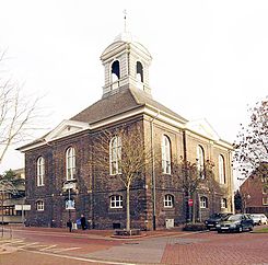
| Lutherhaus (2005), on the right the confluence with Beguinenstrasse | |
| Basic data | |
| place | Wesel |
| District | Old town (historically: Mathena-Vorstadt ) |
| Buildings | Luther House Wesel |
| use | |
| User groups | Motor vehicles , public transport , pedestrian traffic , bicycle traffic |
| Technical specifications | |
| Street length | 314 m |
The Korbmacher Street is a downtown street of Wesel on the Lower Rhine.
location
Korbmacherstraße runs in a north-south direction through the Wesel city center. In the south it turns into Kreuzstrasse at the so-called Mathenakreuz . At Mathenakreuz, these two streets, which are designed as a traffic-calmed area in this section , meet the central Wesel pedestrian zone with the sections Hohe Straße to the east and Viehor to the west. The traffic-calmed area ends in the north at the confluence of Beguinenstraße and Doelenstraße, but the area adjacent to the north is also important for retail. In the northernmost section, the street is mainly characterized by residential developments. At the confluence of Martinistraße and Mölderplatz, the 314-meter-long street turns into Pastor-van-der-Giet-Straße. The latter is only 50 meters long and leads to the northern Weseler city ring. Together with Kreuzstrasse, which ends in the south at Bundesstrasse 58 (Schillstrasse), Korbmacherstrasse is part of the central north-south axis through the inner city center.
history
Korbmacherstraße is not in the historically oldest part of Wesel, but just outside it in the area of Mathena-Vorstadt . In the 14th century, a section of the Wesel city moat ran along today's road. Historically it was called Antoniusstraße, derived from the Antonius Chapel built in 1352 on the edge of the Mathenakreuz. In the 15th century, the Mathenakirche emerged from this chapel as the parish church of the suburb, which was then clearly growing. The current name of the street refers to the basket maker profession . From the 17th century, a house on the corner of Korbmacherstrasse and Beguinenstrasse was used for Protestant-Lutheran church services. The Wesel Lutherans did not have their own church at that time, as the Reformed Church was the dominant Protestant denomination in the city. In 1729 the former house was converted into a church called Lutherhaus .
In the early 20th century, today's pedestrian zone had already developed into the core business area, but the nearby Korbmacherstrasse also had shops. As already planned in the pre-war planning, the Kreuz- und Korbmacherstraße became the primary north-south axis through the city center as part of the reconstruction after the Second World War , replacing a connection further west along the Grosser Markt and Kornmarkt . In 1951 Korbmacherstrasse was one of the first inner city streets with a completed carriageway. As early as November 1949, the first contiguous block of houses to be rebuilt was completed along Viehor and Korbmacherstrasse. The Luther House, the roof of which was burned out, was redesigned during the reconstruction. Instead of the double galleries as part of a high hall, false ceilings were installed and the basement was set up as a community center. On the upper floor a hall was inaugurated in 1954 with a surrounding gallery, which is used for events and concerts.
The southern Korbmacherstraße is characterized by shops, which are mainly smaller specialist shops. Since 2014, the news anchor Jan Hofer , who grew up on Korbmacherstraße, has been investing more in real estate along the street and in 2017 donated outdoor lighting for the Lutherhaus that was used at night.
Individual evidence
- ↑ Street directory 46483 ( Memento of the original from September 15, 2016 in the Internet Archive ) Info: The archive link was inserted automatically and has not yet been checked. Please check the original and archive link according to the instructions and then remove this notice. (strassenverzeichnis.deutschlandblick.com)
- ↑ The Lower Rhine between Xanten and Nijmegen, p. 194
- ↑ Street in Wesel - letter K (wesel.de)
- ↑ Lutherhaus (wesel.de)
- ↑ Research on German Landscapes, Volume 201, p. 10
- ↑ Martin Wilhelm Roelen, Doris Rudolfs-Terfurth (ed.): The reconstruction of the city of Wesel, p. 184
- ^ Martin Wilhelm Roelen, Doris Rudolfs-Terfurth (ed.): The reconstruction of the city of Wesel, p. 108
- ^ Martin Wilhelm Roelen, Doris Rudolfs-Terfurth (ed.): The reconstruction of the city of Wesel, p. 42
- ^ Martin Wilhelm Roelen, Doris Rudolfs-Terfurth (ed.): The reconstruction of the city of Wesel, p. 204
- ↑ Retail in Wesel - Wesel 2012 (wesel.de)
- ↑ Jan Hofer is involved in Wesel (derwesten.de)
- ↑ Tagesschaussprecher Jan Hofer is involved in Wesel (wdr.de)
Coordinates: 51 ° 39 ′ 30.4 " N , 6 ° 36 ′ 59.3" E
