Kotamobagu
| Kota Kotamobagu Kotamobagu |
||
|---|---|---|
|
|
||
| Coordinates | 0 ° 44 ′ N , 124 ° 19 ′ E | |

|
||
| Symbols | ||
|
||
| Basic data | ||
| Country | Indonesia | |
|
Geographical unit |
Sulawesi | |
| province | Sulawesi Utara | |
| ISO 3166-2 | ID-SA | |
| surface | 184.3 km² | |
| Residents | 107,459 (2010) | |
| density | 583 Ew. / km² | |
| Website | www.kotamobagukota.go.id (Indonesian) | |
| politics | ||
| mayor | Ir. Hj. Tatong Bara | |
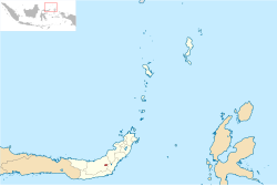
Kotamobagu is a city in the Indonesian province of Sulawesi Utara on the island of Sulawesi . Since January 2, 2007, Kotamobagu has had the status of a city ( Kota ) directly subordinate to the province .
The population at the end of 2010 was 107,459.
Administrative division
Kotamobagu consists of four districts ( Kecamatan ) and 33 subunits ( Kelurahan ).
| District | German name | Population census 2010 |
|---|---|---|
| Kotamobagu Selatan | (South Kotamobagu) | 28,030 |
| Kotamobagu Timur | (East Kotamobagu) | 26,355 |
| Kotamobagu Barat | (West Kotamobagu) | 37,678 |
| Kotamobagu Utara | (North Kotamobagu) | 15,396 |
Individual evidence
- ↑ Jumlah Penduduk Sulawesi Utara Tahun 2010 ( Memento of the original from November 28, 2011 in the Internet Archive ) Info: The archive link was inserted automatically and has not yet been checked. Please check the original and archive link according to the instructions and then remove this notice.
- ^ Biro Pusat Statistics, Jakarta, 2011.

