Kpalimé
| Kpalimé | |

|
|
| 6 ° 54 '36 " N , 0 ° 37' 41" E | |
| Basic data | |
|---|---|
| State : |
|
| Region : | Plateaux |
| Prefecture : | Kloto |
| Residents : | 75,084 (2010) |
According to the 2010 census, Kpalimé or Palimé is the fourth largest city in Togo with 75,084 inhabitants , after Lomé , Sokodé and Kara, and the capital of the prefecture of Kloto in the Plateaux region . It is 120 km from the Togolese capital Lomé on the border with Ghana . The Togolese national road N5 runs through the city from Lomé to Atakpamé .
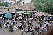
To the southeast of the city lies Mont Agou , with a height of 986 meters the highest mountain in Togo. Because of the climate and the mountain landscape, the city was a popular holiday destination during colonial times. Today the city is known for its fabric and fruit market, which takes place on Tuesdays and Saturdays. Kpalimé was the center of Togolese coffee, cocoa and citrus cultivation. The branch of the economy is in fact no longer available.
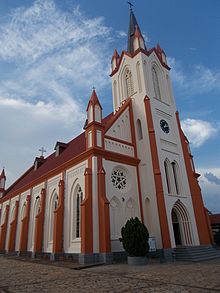
Kpalimé is the seat of the Roman Catholic diocese of Kpalimé . Episcopal church is the Saint-Esprit cathedral .
history
Precolonial phase (before 1890)
Kpalimé, originally called Agomé-Kpalimé, was the place of residence of the Agomé population. The origins are presumably in Yorubaland (today Benin, Nigeria and Togo), in particular in the cities Ifè (religious center) and Oyo (political and administrative center). The people gradually moved west and settled Kétou (Benin), Tado (Togo) and founded the city of Notsé.
King Agokoli, who ruled the city of Notsé in the early 18th century, was a tyrant. The people found refuge in Gamé.
Colonial phase (1890-1960)
eat
Local specialties include palm wine and grilled chicken or grilled fish, served with fufu and peanut sauce.
Attractions
There is a cathedral in the city.
The area around Kpalimé is known for its scenic beauty and tropical climate. The Mount Agou and the mountain Kloto offer on clear days, a view of the Lake Volta . In addition, there are several waterfalls (Tomegbe, Kpoeta, Woatti, Woma, Ykpa, Aklowa, Kpima and Amegape), coffee and cocoa plantations in the immediate vicinity.
Other attractions nearby:
- The Abbaye de l'Ascension Benedictine monastery in Dzogbégan , founded in 1961 by French monks
- The Château Vial , the presidential castle near Kouma Konda
Some traces from the time of the German colony Togo (1884-1919) can still be found in Kpalimé :
- Holy Spirit Cathedral ( Saint-Esprit Cathedral ), extensively renovated in 2003 by the Rottenburg-Stuttgart diocese
- Remnants of the Lomé – Kpalimé railway line built by Germans and the former Kpalimé station , inaugurated on the Kaiser's birthday in 1907
- German colonial station Misahohé with a German cemetery , named after Missa von Esterházy , the childhood sweetheart of the first consul there, Jesko von Puttkamer .
Partnerships
Kpalimé's partner municipalities are Bressuire (since 1991) in the French region of Nouvelle-Aquitaine and Maré (since 2008) within the New Caledonia archipelago belonging to France in the southern Pacific.
Web links
supporting documents
- ↑ 2011 census , accessed on January 7, 2011
- ↑ Abbaye de lAscension de Danyi Dzogbégan-TOGO: Abbaye de lAscension de Danyi Dzogbégan-TOGO. Retrieved May 19, 2018 .
- ↑ Kabossy: Kpalimé, Château Vial. March 23, 2009. Retrieved May 19, 2018 .
- ^ Website Kpalimé

