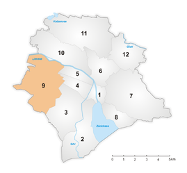
District 9 (City of Zurich)
|
District 9 urban district of Zurich |
|
|---|---|
| Coordinates | 678 616 / 248453 |
| surface | 12.07 km² |
| Residents | 55,765 (2018) |
| Population density | 4620 inhabitants / km² |
| structure | |
| Quarters | |
The circuit 9 is located in the west urban district of the city of Zurich . It includes the districts of Altstetten and Albisrieden, which were incorporated into the city in 1934 .
history
District 9 was created as part of the second incorporation in 1934. In contrast to the other city districts, it never went through a change and since its creation has unchanged comprises the formerly independent communities Albisrieden and Altstetten. The existence of the Grünau (Altstetten) quarter is noteworthy , although it is not officially reported separately by the Statistical Office of the City of Zurich , as it conflicts with the official nomenclature.

