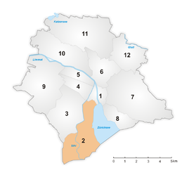
District 2 (City of Zurich)
|
District 2 urban district of Zurich |
|
|---|---|
| Coordinates | 681 789 / 243524 |
| surface | 11.07 km² |
| Residents | 34,877 (December 31, 2018) |
| Population density | 3151 inhabitants / km² |
| structure | |
| Quarters | |
The circuit 2 is an urban district of the city of Zurich and is located on the left bank of Lake Zurich . It comprises the quarters Enge , Wollishofen and Leimbach, which were incorporated into the city in 1893 .
history
District 2 was created as part of the first incorporation in 1893 as Stadtkreis II . Since its inception, it has consistently comprised the formerly independent communities Enge and Wollishofen. The Leimbach quarter was newly created, which includes the hamlets of Unterleimbach and Mittelleimbach , which formerly belonged to the municipality of Enge . The hamlet of Oberleimbach , which formerly belonged to the municipality of Wollishofen , was not incorporated into the municipality, but assigned to the municipality of Adliswil , to which it still belongs today.
Since the revision of the city districts in 1913, which in this case did not result in any changes to the area or real renumbering, Arabic numerals have been used for the numbering, which means that circle 2 has been written since then .
Attractions


