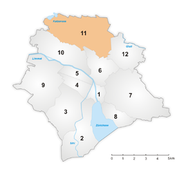
District 11 (City of Zurich)
|
District 11 urban district of Zurich |
|
|---|---|
| Coordinates | 681 699 / 253035 |
| surface | 13.42 km² |
| Residents | 75,344 (2018) |
| Population density | 5614 inhabitants / km² |
| structure | |
| Quarters | |
The circle 11 is the northernmost and 75'344 people (as of 2018) of the most populous urban area of the city of Zurich . It includes the districts of Oerlikon , Seebach and Affoltern, which were incorporated into the city in 1934 . The city districts 11 and 12 in the Glattal are often referred to together as Zurich North .
history
District 11 was created as part of the second incorporation in 1934. District 11 originally included the former communities of Affoltern, Oerlikon, Seebach and Schwamendingen , i.e. all four incorporated communities of the Glatttal. On the occasion of a revision of the city districts, Schwamendingen was reallocated into its own, newly created district 12 in 1971 and divided into three quarters on the drawing board by the statistical office of the city of Zurich . Since then, the administrative division of the city of Zurich has remained unchanged from 1971.
Attractions
Individual evidence
- ^ Districts and Quarters. In: City of Zurich. Presidential Department, accessed on August 1, 2019 .


