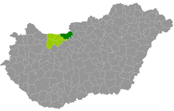
Esztergom County
| circle Esztergomi járás
Esztergom |
|
|---|---|
 Location of the district in Hungary |
|
| Basic data | |
| Country | Hungary |
| County | Komárom-Esztergom |
| Seat | Esztergom |
| surface | 537.5 km² |
| Residents | 91,011 (January 1, 2016) |
| density | 169 inhabitants per km² |
Esztergom (Hungarian Esztergomi járás ) is a district in Komárom-Esztergom County in northern Hungary . It borders Tata County to the west and Tatabánya County to the southwest . In the north the Danube forms the state border with Slovakia , 7 border municipalities lie on the river.
history
The district was established in the course of the Hungarian administrative reform in early 2013 as the successor to the small area of the same name (Hungarian Esztergomi kistérség ) with all 9 municipalities (58.2% of the population). The new district was strengthened by all 15 municipalities (with 43.3% of the area) of the southern small area of Dorog (in Hungarian Dorogi kistérség ), which was dissolved at the end of 2012 . Esztergom County became the largest and most populous county in the county.
Community overview
Esztergom County has an average municipality size of 3,792 inhabitants on an area of 22.40 square kilometers. The population density is the second highest in the county and is higher than the value for the entire county (132). The administrative center is located in the largest city, Esztergom , in the north of the district.
| local community | status | Origin small area |
population | Area (km²) | Population density (inh / km²) |
||
|---|---|---|---|---|---|---|---|
| October 01, 2011 | 01/01/2013 | 01/01/2016 | |||||
| Annavölgy | local community | Dorog | 941 | 931 | 935 | 4.83 | 193.6 |
| Bajna | local community | Dorog | 1.928 | 1.937 | 1,899 | 37.27 | 51.0 |
| Bajot | local community | Esztergom | 1,538 | 1,607 | 1,596 | 16.44 | 97.1 |
| Csolnok | local community | Dorog | 3,230 | 3,166 | 3,068 | 18.70 | 164.1 |
| Dág | local community | Dorog | 932 | 948 | 938 | 11.89 | 78.9 |
| Dorog | city | Dorog | 12.199 | 11,905 | 11,855 | 11.54 | 1027.3 |
| Dömös * | local community | Esztergom | 1,167 | 1,144 | 1,087 | 23.99 | 45.3 |
| Epöl | local community | Dorog | 643 | 647 | 614 | 12.52 | 49.0 |
| Esztergom * | city | Esztergom | 28,926 | 28,550 | 27,990 | 100.11 | 279.6 |
| Kesztölc | local community | Dorog | 2,626 | 2,606 | 2,521 | 22.00 | 114.6 |
| Lábatlan * | city | Esztergom | 5,033 | 4,968 | 4,794 | 26.37 | 181.8 |
| Leányvár | local community | Dorog | 1,704 | 1,744 | 1,739 | 7.26 | 239.5 |
| Máriahalom | local community | Dorog | 677 | 643 | 569 | 10.85 | 52.4 |
| Mogyorósbánya | local community | Esztergom | 862 | 853 | 832 | 7.32 | 113.7 |
| Nagysáp | local community | Dorog | 1,487 | 1,531 | 1,422 | 24.78 | 57.4 |
| Nyergesújfalu * | city | Esztergom | 7,621 | 7,550 | 7,378 | 39.63 | 186.2 |
| Piliscsév | local community | Dorog | 2,356 | 2,321 | 2,334 | 24.91 | 93.7 |
| Pilismarót * | local community | Esztergom | 1,977 | 1.991 | 1,986 | 44.58 | 44.5 |
| Sárisáp | local community | Dorog | 2,770 | 2,740 | 2,663 | 14.22 | 187.3 |
| Süttő * | local community | Esztergom | 2,071 | 2,061 | 2,055 | 34.47 | 59.6 |
| Tát * 1 | city | Esztergom | 5,302 | 5,327 | 5,241 | 12.06 | 434.6 |
| Tokod | Large community | Dorog | 4.143 | 4.137 | 3,981 | 14.91 | 267.0 |
| Tokodaltáró | local community | Dorog | 2,963 | 2,922 | 2,836 | 5.27 | 538.1 |
| Úny | local community | Dorog | 688 | 673 | 678 | 11.58 | 58.5 |
| Esztergom County | 93,784 | 92.902 | 91.011 | 537.50 | 169.3 | ||
* Border towns to Slovakia
1 The large municipality of Tát was granted town charter in mid-July 2013.
swell
PDF and XLS files: 2011
Census :
2013:; 2016:
Individual evidence
- ↑ KSH: 2011. Évi Népszámlálás. In: 3. Területi adatok. KSH, accessed on December 26, 2016 (Hungarian, also via: http://www.terezvaros.hu/testuleti/nepsz2011-3/pdf/nepsz2011_03_11.pdf ).
- ↑ KSH: Regional data - Komárom-Esztergom county. KSH, accessed on December 26, 2016 (English, 4th Data on Localities).
- ↑ KSH: Gazetteer of Hungary, 1st January, 2013. KSH, accessed on March 25, 2017 (Hungarian / English).
- ↑ KSH: Gazetteer of Hungary, 1st January, 2016. KSH, accessed on March 25, 2017 (Hungarian / English).