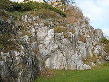
Kreuzberg (Pleystein)
The Kreuzberg is a quartz rock in Pleystein in the Upper Palatinate district of Neustadt an der Waldnaab in Bavaria .
location
The quartz rock is located in the center of the town of Pleystein. It is designated as a natural monument and part of the Northern Upper Palatinate Forest Nature Park . The Catholic pilgrimage church of the Holy Cross is located on the prominent cliff .
description
The Kreuzberg is a quartz rock about 30 meters high. The hard core of a pegmatite stick is the city's landmark. The quartz rock became famous for its beautiful and rare minerals . Due to a rock fall in the 1970s, unweathered material with a “crystal cellar” came to light.
The formation of the quartz rock is related to the granites that formed around 300 million years ago in the crystalline basement mountains of Eastern Bavaria. In what is now Central and Western Europe, two continents collided and the mighty Variscan Mountains piled up . The rocks that previously lay on the ocean floor between the continents were pushed into the depths during the collision. Under the high pressure and temperature conditions prevailing there, they were converted and partially melted. Ember, liquid magma rose to weak areas in the earth's crust and solidified under the earth's surface. Granite bodies such as the Flossenbürger granite and pegmatite sticks such as in Hagendorf or here in Pleystein formed.
Pegmatites belong to a rare rock group that is characterized by large to giant-grain mineral formations. They arise from remnants of igneous rock melt and often contain high concentrations of rare elements. The Pleystein counts as the neighboring pegmatites of Hagensdorf north / south to the quartz feldspar - phosphate -Pegmatiten. A zonal structure is typical here, the quartz core of which has a cap made of phosphate minerals and is encased in the shape of a shell by a feldspar and aplit zone. Here in Pleystein only the quartz core and the underlying aplit on the east side have been preserved.
The former deposits in Hagendorf were more fully documented and were largely dismantled in the past. In Hagendorf-Süd, feldspar was mainly obtained for the ceramic industry, as well as phosphate minerals and, above all, the lithium phosphate triphyline .
Persistent movements of the earth's crust divided the Variscan Mountains into individual smaller massifs over the course of millions of years. This is how today's low mountain range originated. Weathering and erosion exposed the granites that were originally crystallized deep underground. Today they form part of the land surface. From this protrudes the hard quartz rock of the Kreuzberg, which was more resistant to erosion and is now a form of landscape that can be seen from afar.
The Kreuzberg consists of light smoky quartz and white milk quartz . The place is famous for the pink rose quartz that appears in places . From 1851 to 1920 quartz was mined and used as a raw material for porcelain and glass production. This created the almost vertical east side of the Kreuzbeges.
Pleyenstein, the "city on shining stone" (Old High German "pleyen" means to shine or shine) did not want to lose its landmark and so in 1920 dismantling was forbidden. Today the Kreuzberg is protected as a natural monument.
Geotope
Kreuzberg has been designated by the Bavarian State Office for the Environment (LfU) as a geoscientifically particularly valuable geotope (geotope number: 374A015). It was also awarded the official seal of approval for Bavaria's most beautiful geotopes by the LfU .
Individual evidence
- ↑ Location of the geotope in the Bavaria Atlas (accessed on November 17, 2017).
- ↑ Bavarian State Office for the Environment, Geotop Kreuzberg in Pleystein (accessed on November 17, 2017).
- ↑ Bavaria's most beautiful geotopes, Kreuzberg in Pleystein (accessed on November 17, 2017)
Web links
Coordinates: 49 ° 38 ′ 46.6 ″ N , 12 ° 24 ′ 40.9 ″ E


