Kreuzbruch (Liebenwalde)
|
Cross break
City of Liebenwalde
Coordinates: 52 ° 50 ′ 27 ″ N , 13 ° 25 ′ 31 ″ E
|
|
|---|---|
| Height : | 39 m |
| Incorporation : | October 26, 2003 |
| Postal code : | 16559 |
| Area code : | 033054 |
|
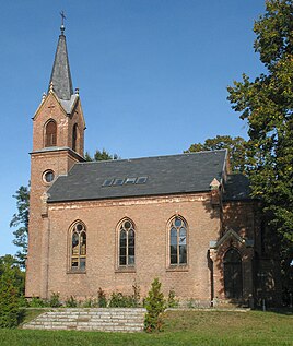
Former village church
|
|
Kreuzbruch is a district of the town of Liebenwalde in the Oberhavel district in Brandenburg .
geography
The place is four kilometers south-southeast of Liebenwalde in the Barnim Nature Park . In the west of the district, large parts of the district form the FFH area of the same name . Even larger shares belong to the bird sanctuary and the Obere Havelniederung landscape conservation area .
history
The origin of the place is based on a decree by Friedrich Wilhelm I from 1717, with which he ordered the reclamation of the Creutzbruch and the Wahse . In the following year, families predominantly from Switzerland began to build the new colony.
The village church from the 19th century was profaned and sold for private use.
The Kreuzbruch station on the Heidekrautbahn was in operation from 1905 to 1997.
Web links
- Cross break in the genealogical directory
- Information about the place on liebewalde.de
Individual evidence
- ↑ City of Liebenwalde - districts according to § 45 municipal constitution. In: service.brandenburg.de. Ministry of the Interior and Local Affairs of the State of Brandenburg, accessed on April 7, 2015 .
- ↑ Map service for protected areas. Federal Agency for Nature Conservation, accessed on April 7, 2015 .
- ↑ Kreuzbruch - Chronicle. City of Liebenwalde, accessed April 7, 2015 .
