Kropfbach (Loisach)
|
Kropfbach Unterlaufname: Mühlbach |
||
|
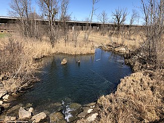
Mühlbach below Bartlmämühle |
||
| Data | ||
| Water code | EN :? | |
| location | Garmisch-Partenkirchen district , Upper Bavaria , Germany | |
| River system | Danube | |
| Drain over | Loisach → Isar → Danube → Black Sea | |
| Source height | 1300 m | |
| muzzle |
Loisach coordinates: 47 ° 38 '6 " N , 11 ° 12' 41" E 47 ° 38 '6 " N , 11 ° 12' 41" E |
|
| Mouth height | approx. 626 m | |
| Height difference | approx. 674 m | |
| Bottom slope | approx. 19% | |
| length | approx. 3.6 km | |
| Left tributaries | Einödbach | |
| Right tributaries | Kräuterbach | |
The Kropfbach , called Mühlbach in the lower reaches between Bartlmämühle and its confluence with the Loisach , is a right tributary to the Loisach in Upper Bavaria .
It arises from trenches on the northern slopes of the Eckleiten , leaves the mountainous terrain in the direction of the Murnauer Moos. There it passes the Bartlmämühle and is only called Mühlbach. Then it crosses under the A 95 and flows into the Loisach from the right.
Individual evidence
Web links
- The course of the Kropfbach in the Bavaria Atlas
