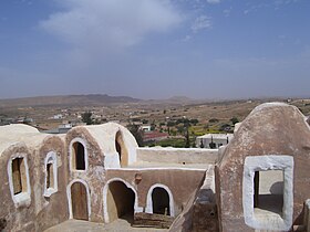
Ksar Haddada
| Ksar Haddada |
||
|---|---|---|
| Ksar Haddada - place and landscape | ||
| administration | ||
| Country |
|
|
| Governorate | Tataouine | |
| Délégation (s) | Tataouine Sud | |
| Post Code | 3261 | |
| Demographics | ||
| population | 1500 pop. | |
| geography | ||
| height | 400 m | |
|
|
||
| Coordinates | 32 ° 55 ' N , 10 ° 16' E | |
Ksar Haddada or Ksar Hadada ( Arabic قصر حدادة) is a Berber village with around 1,500 inhabitants in the Tataouine Governorate in southern Tunisia .
location
Ksar Haddada is located in a valley basin in the almost desert-like Dahar Mountains at an altitude of approx. 400 m above sea level. d. M. about 30 km (driving distance) northwest of Tataouine .
economy
The inhabitants of earlier centuries lived as farmers and ranchers in a semi-nomadic way of life ( transhumance ), which continued into the first half of the 20th century. The small fields received some rain in winter and were already harvested in April; in summer the cattle were moved to higher regions of the Dahar mountainous region. Since the 1940s, this way of life has been gradually abandoned - also because of the increasingly less rainy climate. Many men work in the cities of the north or on Djerba ; some have brought their families to join them. The place became a tourist destination at the end of the 20th century.
history
As in almost all Berber settlements in the Maghreb, there are no records of the history of the place. It may also have served as a resting and storage place for trade caravans .
Attractions
Ksar Haddada consists of numerous mostly two-storey storage vaults ( ghorfas ), in which in earlier times food supplies (grain, oil, beans, lentils, dates etc.), but also other valuables (agricultural and household utensils, weapons etc.) of the villagers were stored. The buildings are vaulted because - unlike the Agadirs of Morocco - branches and reeds were not available in sufficient quantities for the construction of flat roofs.
Others
In some Star Wars films, Ksar Haddada was used as a film set for Mos Espa .
Surroundings
The mountain villages of Chenini and Douiret are about 35 km (driving distance) to the southwest .
literature
- Hédi Ben Ouezdou: Découvrir la Tunisie du Sud. De Matmata à Tataouine - ksour, jessour et troglodytes. Faculté des sciences humaines et sociales, Tunis 2001, ISBN 978-9973-31-853-4 .


