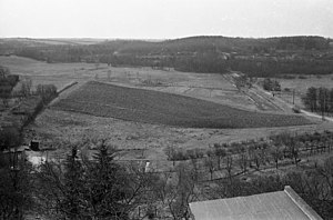
Kuckucksberg (Kiel)
| Kuckucksberg | ||
|---|---|---|
|
View from Preetzer Strasse (1963) |
||
| height | 55.2 m (according to other information 56 m ) | |
| location | Wellsee , Kiel , Schleswig-Holstein , Germany | |
| Mountains | Schleswig-Holstein hill country | |
| Dominance | 0.636 km → Kölenberg | |
| Notch height | 20 m | |
| Coordinates | 54 ° 17 '46 " N , 10 ° 9' 24" E | |
| Topo map | map | |
|
|
||
| Type | Terminal moraine of the last glacial period | |
The Kuckucksberg is located south of the Kieler Langsee in the 1996 designated landscape protection area Langsee, Kuckucksberg and the surrounding area . According to the official city atlas of Kiel, it is 55.2 m high.
On it there is a forest with small bodies of water that have partially dried up . The Konrad-Adenauer-Damm ( Bundesstrasse 76 ) runs through the area .
A military bunker was built on the Kuckucksberg during the Second World War , which had 200 shelter sites. Since 1964, the section of the former circular path that leads past the elevation has been called Kuckucksweg .
Individual evidence
- ^ A b Landeshauptstadt Kiel (Ed.): Kuckucksweg . In: Kieler Straßenlexikon, accessed on August 11, 2019.
- ↑ a b c landscape protection area "Langsee, Kuckucksberg and surroundings" .
- ↑ State Capital Kiel - Office for Building Regulations, Surveying and Geoinformation (Ed.): Stadtatlas Kiel - 1: 7500 . 2015, ISBN 978-3-9808839-9-3 , p. 51.
- ^ Ingo Kroll: Bunker and tunnel in Kiel . 2015 ( online , accessed August 11, 2019).

