Kiel-Wellsee
|
Wellsee
City of Kiel
Coordinates: 54 ° 17 ′ 21 ″ N , 10 ° 9 ′ 58 ″ E
|
|
|---|---|
| Height : | 44 m |
| Area : | 5.14 km² |
| Residents : | 5154 (Dec. 31, 2014) |
| Population density : | 1,003 inhabitants / km² |
| Incorporation : | April 26, 1970 |
| Postal code : | 24145 |
| Area code : | 0431 |
|
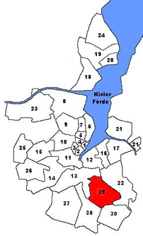
Location of Wellsee in Kiel
|
|
Wellsee is a district in the south of Kiel .
History & Development
Wellsee was first mentioned in 1270 under the names Wilse and Welse. Welse is Slavic and means Erlensee. The old village was in 1850 twelve full- and half hooves and five skating - and cultivation create . In 1970 Wellsee was incorporated into Kiel, thereby expanding the Kiel city area by 501 hectares . From 1911 to 1961 Wellsee was the station of the Kleinbahn Kiel – Segeberg , whose tracks were removed in 1962.
In the 1990s, an approx. 4 km² large new building area was advertised west of the old village center. Half of it has so far been developed through terraced houses and partially subsidized apartment buildings, a further construction phase with individual houses is currently being implemented. The streets are named after resistance fighters such as Claus Schenk Graf von Stauffenberg (Stauffenbergring) or Carl Friedrich Goerdeler (Goerdelerring).
Known places
- The Wellsee is one of the standing waters in Schleswig-Holstein . It is a popular local recreation area.
- In the Wellsee industrial area, many companies from a wide variety of industries have production and work sites.
- The sports field on Liselotte-Herrmann-Straße is home to the local sports club SC Fortuna Wellsee.
schools
- Wellsee Elementary School
- Youth Development Center Kiel - Wellsee Education Center
Web links
- Green roads in the city
- Kiel district Wellsee in the Stadtwiki Kiel
Individual evidence
- ↑ The population in the Kiel districts in 2014 . (PDF) State capital Kiel
- ↑ Hans-G. Hilscher, Dietrich Bleihöfer: Wellseedamm. In: Kiel Street Lexicon. Continued since 2005 by the Office for Building Regulations, Surveying and Geoinformation of the State Capital Kiel, as of February 2017 ( kiel.de ).
- ↑ Development plan of the city of Kiel. (PDF; 3.5 MB).
- ↑ City map of the city of Kiel published by the city of Kiel with detailed district boundaries.

