Rönne (Kiel)
|
Ronne
City of Kiel
Coordinates: 54 ° 16 ′ 9 ″ N , 10 ° 10 ′ 40 ″ E
|
|
|---|---|
| Height : | 50 m |
| Area : | 4.78 km² |
| Residents : | 428 (Dec. 31, 2014) |
| Population density : | 89 inhabitants / km² |
| Incorporation : | April 26, 1970 |
| Postal code : | 24145 |
| Area code : | 0431 |
|
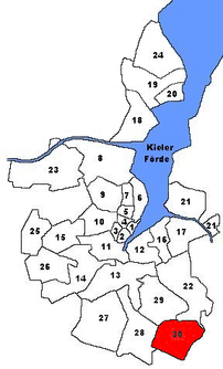
Location of Rönne in Kiel
|
|
Rönne is a district in the south of Kiel . With 428 inhabitants (as of December 31, 2014), Rönne is the smallest district in terms of population. Compared to other districts of Kiel, Rönne has an average area with sparsely populated areas and a very low proportion of foreigners.
The Wohlersberg in Rönne is 74.2 m above sea level. NN the highest point in Kiel.
history
Rönne was first mentioned in 1300 under the name Renne. The name means in Low German Rinne. In 1970 Rönne was incorporated into Kiel and enlarged the Kiel city area by 479 hectares .
Rönne has kept its village character to this day. There is a fire extinguishing pond in the center of the village . The “Puck'scher Hof”, a half-timbered house built in 1834 , which was used as an inn until 1966 and is now used as a residential and farm building, is one of the cultural monuments in Rönne, see the list of cultural monuments in Kiel-Rönne .
Educational institutions
Rönne does not have its own elementary school, the more than 200 year old elementary school Wellsee is responsible. The former school building still exists.
economy
The district area is mainly used for agriculture.
South of the village center is located on a meadow between the streets "Wolblöken" and "To the Forest", a ham radio - antenna system (ID DL0SHF). It works with the IQSH (Institute for Quality Development at Schleswig-Holstein Schools) and carries out measurements for schools and science (Institute for Extraterrestrial Physics at the University of Kiel ) in various areas, such as weather data or traffic flows. Since 2009 data from the NASA solar probes STEREO A and B have been received, and since 2016 data from the ACE satellite . 6 different parabolic antennas with a diameter of 1.2 to 9 m and a frequency range of 1 to 24 GHz are currently available for the measurements .
Web links
- Kiel district Rönne in the Stadtwiki Kiel
Individual evidence
- ↑ The population in the Kiel districts in 2014 . (PDF) State capital Kiel
- ↑ Kiel districts 2017. Accessed on January 8, 2020 .
- ↑ City map of the city of Kiel published by the city of Kiel with detailed district boundaries.
- ↑ a b Kiel districts. Volume 5: The outskirts of Kiel in the west and south. Borchard & Wegner, Kiel 2009, ISBN 978-3-00-029094-7 , p. 116, text by Ekkehard Buchhofer.
- ↑ Kiel districts. Volume 5: The outskirts of Kiel in the west and south. Borchard & Wegner, Kiel 2009, ISBN 978-3-00-029094-7 , p. 152, text by Ekkehard Buchhofer.
- ^ Elementary school Kiel-Wellsee
- ↑ ACE Ground Station Tracking Plots - Details
- ↑ DLØSHF satellite receiving station, amateur radio station and radio observatory for schools and universities

