
Hasseldieksdamm
|
Hasseldieksdamm
City of Kiel
Coordinates: 54 ° 18 ′ 57 ″ N , 10 ° 4 ′ 27 ″ E
|
|
|---|---|
| Area : | 3.39 km² |
| Residents : | 2797 (Dec. 31, 2014) |
| Population density : | 826 inhabitants / km² |
| Incorporation : | April 1, 1910 |
| Postal code : | 24109 |
| Area code : | 0431 |
 Location of Hasseldieksdamm in Kiel
|
|
Hasseldieksdamm is a district of Kiel .
history
In the Kiel city register from 1264 to 1289, the village of Hassenthorpe was first mentioned in 1270 on the site of today's Hasseldieksdamm. Documentary evidence of the whereabouts of the village is missing for the following decades. The fish ponds on both sides of the Hasseldieksdammer wood were probably still used economically. In 1543 the fish pond "Hasseldieksdamm" was mentioned again. The Kiel city villages (part of the foundation assets of the Heiligengeist Hospital) were leased to Duke Adolf I in 1572 . Hasseldieksdamm became part of the Meierhof Kronshagen , which then became an estate in 1667.
In 1768 Gut Kronshagen was converted into an office, the Hoffeld parceled out and an expansion of the village of Hasseldieksdamm initiated. The large fish ponds had already been drained. The area could now be used for agriculture.
On April 1, 1910, the independence of the village of Hasseldieksdamm ended. It was incorporated into Kiel with Hassee , Gaarden-Süd , Ellerbek and Wellingdorf .
Since the incorporation, Hasseldieksdamm has changed less than other Kiel districts. The district is connected to Kiel city center via the Hofholzallee and Scandinaviendamm arteries . The Hofholzallee is characterized by simple villas. The old village center is located south of Hofholzallee . In Martenshofweg and Melsdorfer Straße , some thatched hall houses and cottages have been preserved. At the corner of Hofholzallee and Russeer Weg , smaller settlements were initially built after the Second World War, and around 1960 the Kieler Housing Association (KWG) built the “Neu-Hasseldieksdamm” multi- storey housing estate on Im Waldwinkel . The “Sprottenkiste” high-rise block, which also houses a supply center, forms the center of this settlement. However, this construction method is an exception in Hasseldieksdamm, which is otherwise characterized by villas and single-family houses, in contrast to the neighboring large housing estate Mettenhof .
schools
- Gorch Fock School (founded 1938)
- Free Waldorf School Kiel (founded 1976)
Churches
- Erlöserkirche (Evangelical Lutheran): Foundation stone laid on April 27, 1957 and consecration on September 29, 1957
- Raphael Church (anthroposophical): Foundation stone laid on September 2, 1984 and consecration on September 22, 1985
See also
Recreation
- Forest "Hofholz" - A granite stone with the year 1810 reminds of the enclosure of the forest.
- Forest “Hasseldieksdammer Gehölz” - red beech and mixed beech forest .
- Animal enclosure Hasseldieksdamm - animal species: aurochs , bison , bison , sika deer and Scottish highland cattle .
- Alte Stadtgärtnerei Kollhorst - the first nature experience space in Schleswig-Holstein since 1994 .
photos
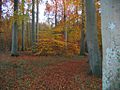
Hasseldieksdammer wood in autumn

Hasseldieksdammer Gehölz + Julienluster Weg

Gorch Fock School in Hasseldieksdamm


Web links
- http://www.hasseldieksdamm.de
- Green roads in the city
- Kiel district Hasseldieksdamm in the Stadtwiki Kiel
Individual evidence
- ↑ The population in the Kiel districts in 2014 . (PDF) State capital Kiel
- ↑ a b Hedwig Sievert: Hasseldieksdamm . Vol. 42 of the series Communications of the Society for Kiel City History, Kiel 1952.
- ↑ Kiel districts. Volume 5: The outskirts of Kiel in the west and south. Borchard & Wegner, Kiel 2009, ISBN 978-3-00-029094-7 , p. 54, text by Ekkehard Buchhofer.
- ↑ http://waldorfschule-kiel.de/start/schule/chronik2.html
- ↑ Werner Jensen: History of Hasseldieksdamm: parish Hasseldieksdamm. In: Hasseldieksdammer Rundbrief, No. 11, 3/2003.
- ↑ Werner Jensen: From the history of Hasseldieksdamm: "The Waldeck restaurant". In: Hasseldieksdammer Rundbrief, No. 9, 1/2003.
- ↑ http://www.kiel.de/touristik/kiel_erkunden/gruene_wege/station.php?x=249
- ↑ https://www.kiel.de/de/umwelt_verkehr/umweltwegweiser.php?view=keyword&id=767
1 old town | 2 suburbs | 3 Parade ground | 4 Damperhof | 5 Brunswik | 6 Düsternbrook | 7 Blücherplatz | 8 Wik including Steenbek-Projensdorf | 9 Ravensberg including Stinkviertel and Marineviertel | 10 Schreventeich | 11 Südfriedhof | 12 Gaarden-Ost | 13 Gaarden-Süd and Kronsburg | 14 Hassee | 15 Hasseldieksdamm | 16 Ellerbek | 17 Wellingdorf | 18 Holtenau | 19 Pries | 20 Friedrichsort | 21 Neumühlen-Dietrichsdorf including the Oppendorf settlement | 22 Elmschenhagen including Kroog | 23 Suchsdorf | 24 Schilksee | 25 Mettenhof | 26 Lake Russe | 27 Meimersdorf | 28 Moorsee | 29 Wellsee | 30 Ronne