Damperhof
|
Damperhof
City of Kiel
Coordinates: 54 ° 19 ′ 36 ″ N , 10 ° 8 ′ 7 ″ E
|
|
|---|---|
| Area : | 45.8 ha |
| Residents : | 3319 (Dec. 31, 2014) |
| Population density : | 7,247 inhabitants / km² |
| Postal code : | 24103 |
| Area code : | 0431 |
|
Location of Damperhof in Kiel
|
|
Damperhof is a district of Kiel .
Mansion
The manor house of the original Damperhof was located on the corner of Kleiner Kuhberg and Waisenhofstrasse near today's Sparkassen-Arena Kiel .
history
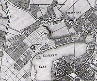
The Damperhof land and the things belonging to it got their name from the former owner, Mrs. Margarethe Hedwig von Ahlefeld auf Damp und Oehe. In 1697 she acquired the farm and the land and named it after the name of her family estate "Damp". The Conference Councilor and Vice Chancellor Friedrich Gabriel Muhlius , who had been registered as the owner since 1769, ordered in his will the establishment of a “permanent orphanage” on the Damperhof. On April 27, 1842, the Damperhof land came into the possession of the city of Kiel (leasing contract with the Muhlius' orphanage fund). Around the middle of the 19th century the city undertook the development of a new residential area for the first time. With the Lorentzen Plan (1846–1854), a street plan was developed on the so-called Damperhof land with straight streets crossing at right angles. The streets belonging to the district were built: Bergstrasse , Legienstrasse (formerly Fährstrasse), Gartenstrasse, Muhliusstrasse and Lorentzendamm. The area to the west of Fleethörn and Rathausstrasse belonging to the estates is now part of the Exerzierplatz district . In the city map of Thalbitzer 1853, the streets mentioned are drawn in without names. In the initial plans, the site was divided into 60 plots . By 1856, 93 parcels were finally achieved through further divisions in order to be able to offer the plots at affordable prices.
Known places
- Small keel
- Hiroshimapark - Undeveloped park between Rathausstrasse, Fleethörn and Lorentzendamm.
- Rosemarie-Kilian-Park - Park in the Karree Knooper Weg, Teichstraße, Lehmberg, Mittelstraße
- Förde Sparkasse
schools
- Muhliusschule - elementary school with all-day care, called Carl-Loewe-Schule from 1948–1988
- Adult Education Center of the State Capital Kiel (VHS)
- Muthesius Academy of Art
See also
Web links
- Kiel district Damperhof in the Stadtwiki Kiel
Individual evidence
- ↑ The population in the Kiel districts in 2014 . (PDF) State capital Kiel
- ↑ a b c Vera Stoy: Kiel on the way to the big city: the urban development up to the end of the 19th century . Ludwig, Kiel 2003, ISBN 3-933598-28-1 , p. 94 .
- ↑ Hans-G. Hilscher, Dietrich Bleihöfer: Damperhofstrasse. In: Kiel Street Lexicon. Continued since 2005 by the Office for Building Regulations, Surveying and Geoinformation of the State Capital Kiel, as of February 2017 ( kiel.de ).
- ↑ City map of the city of Kiel published by the city of Kiel with detailed district boundaries.
- ↑ Kiel.de

