Kuril lake
| Kuril lake | |
|---|---|

|
|
| Geographical location | Kamchatka Peninsula ( Russia ) |
| Drain | Osjornaya |
| Islands | Serdtze Alaida |
| Data | |
| Coordinates | 51 ° 27 ' N , 157 ° 7' E |
| Altitude above sea level | 104 m |
| surface | 77 km² |
| length | 12 km |
| width | 9.9 km |
| volume | 15 km³ |
| Maximum depth | 316 m |
| Middle deep | 195 m |
| Catchment area | 316 km² |
|
particularities |
Caldera lake |
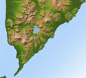
The Kurile Lake ( Russian Курильское озеро Kurilskoje Ozero ) is a caldera on the Russian peninsula of Kamchatka near the southern tip.
The caldera was formed around 8,400 years ago during a massive volcanic eruption of magnitude 7 on the volcanic explosion index (VEI), during which 140–170 cubic kilometers of tephra were ejected. This makes this eruption one of the strongest in the Holocene (since the last Ice Age). The first eruptions probably took place in a lake that was located on the site of today's Kurilensee. After a crater had formed above the water level, there were initially Plinian eruptions ; later pyroclastic currents formed , which spread in all directions up to 50 kilometers. Up to 150 meters thick layers of pumice stone can be found in the vicinity of the lake . Ash fell over large parts of Kamchatka and was mainly distributed to the northwest, where it can still be detected 1,000 kilometers away. The emptied magma chamber collapsed and formed an 8 by 14 kilometer caldera. The eruption was preceded by a dormant period of at least 1500 years.
After the caldera was formed, the volcanoes Ilinskaja Sopka in the northeast and Diki Greben in the west of the lake were formed. In addition, several lava domes formed . One of them is Serdtze Alaida , currently a small island in Lake Kuril, which rises from a depth of around 300 meters.
The lake is 104 meters above sea level, the maximum depth is 316 meters. Shore terraces show that the water level used to be up to 150 meters higher. At present, the Kuril Sea drains westward over the Osjornaya River into the Sea of Okhotsk ; an older drain ran east into the Pacific Ocean .
literature
- NE Zaretskaja et al .: Radiocarbon dating of the Kurile Lake caldera eruption (South Kamchatka, Russia) (PDF file; 927 kB) . In: Geochronometria. 20, 2001, ZDB -ID 58330-3 , pp. 95-102.
- VV Ponomareva et al .: The 7600 ( 14 C) year BP Kurile Lake caldera-forming eruption, Kamchatka, Russia. Stratigraphy and field relationships. In: Journal of Volcanology and Geothermal Research. 136, 3–4, 2004, ISSN 0377-0273 , pp. 199–222 (English, pdf, 2.2 MB).
Web links
- Kurilensee in the Global Volcanism Program of the Smithsonian Institution (English)
- Kuril Lake caldera near Holocene Kamchatka volcanoes (English)
- Kuril Lake at Kronotsky State Natural Biosphere Reserve (English)
