Kyrillpfad Schanze
| Kyrillpfad Schanze | |
|---|---|
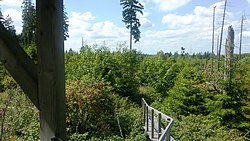
 View from the observation deck in 2017 |
|
| Data | |
| length | approx. 1 km |
| location | Jump |
| Start / finish point |
Schanze 51 ° 7 ′ 45.2 ″ N , 8 ° 22 ′ 42.2 ″ E |
| Type | Educational trail |
| The highest point | 739 |
| Lowest point | 720 |
| Level of difficulty | moderate |
| season | all year round |
| Viewpoints | Viewing platform |
The Kyrillpfad Schanze is a sightseeing and adventure trail in the Schanze district of the town of Schmallenberg .
On the night of 18 to 19 January 2007 The pulled over North Rhine-Westphalia the hurricane Kyrill away and left in the woods of Schmallenberg great damage. Most of the main paths in the affected forest areas were cleared again in mid-2007. The rangers in South Westphalia came up with the idea not to work up part of the Kyrill area and to leave it to nature and to preserve this area as a visual object and adventure trail for the effects of the hurricane. In the course of time, it should also be possible to clearly show how the storm surfaces regenerate themselves.
A 3.5 hectare area owned by the state of North Rhine-Westphalia was found in Schanze. A concept was drawn up in consultation with the Upper Sauerland Regional Forestry Office. With the creativity and personal efforts of the rangers of the Landesbetrieb Wald und Holz NRW, an approximately 1000 meter long path through the Kyrill area with wooden walkways and bridges over fallen trees, ups and downs, past impressive spruce roots . A viewing platform was built in the center of the area. A section of 250 meters has been designed to be barrier-free so that wheelchair users and families with small children can also visit the viewing and adventure trail. The path extends over an altitude of 720 to 739 meters .
In May 2008 the sightseeing and adventure trail was inaugurated. It starts at the Schanze ranger station and ends there nearby.
Foxglove and wood-herb were the first plants to reclaim nature. This was followed by blackberry - and elderberry bushes . After 7 years the regrown vegetation also consisted of mountain ash , maple , beech and spruce . After 11 years, according to the rangers, a balance was established in the vegetation.
Web links
Individual evidence
- ↑ Cyril Path: The Calm After the Storm.Retrieved November 25, 2019.
- ↑ a b Thematic trail Kyrill -pfad Schanze: Views after the storm . Retrieved November 25, 2019.
- ↑ a b Kyrill-path Schmallenberg-Schanze: death and new birth. Accessed on November 25, 2019.
