Längsee (Tyrol)
| Längsee | ||
|---|---|---|

|
||
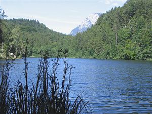
| Längsee, in the background the Tame Kaiser | ||
| Geographical location | Thierberg near Kufstein , Tyrol , Austria | |
| Tributaries | Brook | |
| Drain | underground to the Hechtbach → Kieferbach | |
| Data | ||
| Coordinates | 47 ° 36 '2 " N , 12 ° 9' 21" E | |
|
|
||
| surface | 4.6 ha | |
| Maximum depth | 20 m | |
The Längsee is the most inaccessible of the 6 lakes west of Kufstein . It is in the middle of a forest and has very dark water.
The lake has only a small stream as a tributary. The Längsee is not very popular as a bathing lake, as its beach has no sunbathing areas, but almost exclusively steep banks; on the other hand, water temperatures of up to 25 ° C can be measured in good summers (such as at the beginning of August 2014).
The "Thierberg Lakes" (Pfrillsee, Längsee, Hechtsee, Egelsee) are tectonic phenomena, small collapse basins that may have been favored by cavities or other karst phenomena. However, the Inntal Glacier had cleared them in the last Ice Age, dug them out and dammed them up with moraine debris and meltwater sediments.
However, the Längsee has a strong tendency to silt up. Its outflow disappears in a karst hole, emerges behind a hill to the west and joins the Hechtbach, which is the natural inflow of the Hechtsee.


