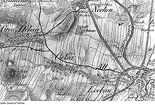
Lärchenberg
| Lärchenberg | ||
|---|---|---|
| height | 330.8 m above sea level NN | |
| location | Germany , Saxony | |
| Mountains | Lusatian highlands | |
| Coordinates | 51 ° 5 '26 " N , 14 ° 38' 17" E | |
|
|
||
| rock | Granodiorite , lamprophyr | |
The Lärchenberg (330.8 m) is a mountain in the Oberlausitzer Bergland southwest of Löbau .
The survey is called “Lärchenhübel” by the residents of the area and “Fichtel Berg” by Oberreit. It is located in the corridor of Oelsa and consists of granodiorite , which runs through a lamprophyre duct that was previously mined. The summit is covered by 1.7 hectares of deciduous trees with individual larches, in which there are some residential and weekend houses. The elevation is part of a small chain of hills that accompanies the Littetal in the north. This begins with the Kleiner Landeskrone (376.9 m) and continues over the Bubenik (375.9 m), Fuchsberg (345.0 m) and the Fichtelberg (341.3 m) to the Lärchenberg to get to the Nonnenberg ( 314.9 m) to end at Großschweidnitz . The exposed location of the mountain allows a view of the neighboring town of Löbau and the Löbauer Berg behind it , further over part of the arable hill country and the East Lusatian foothills to the Kottmar . The restaurant Lindenhof am Heiteren Blick was about 500 m southwest of the Lärchenberg on the S 151 (Löbau-Lawalde road). Immediately next to it there used to be an elevated water tank, which the city of Löbau had put into operation in 1891.
literature
- Between Strohmberg, Czorneboh and Kottmar (= values of our homeland . Volume 24). 1st edition. Akademie Verlag, Berlin 1974.

