Lütjensee (Lütjensee)
| Lütjensee | ||
|---|---|---|

|
||
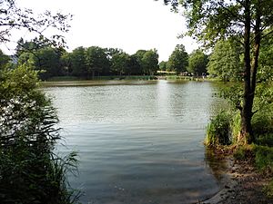
| North beach of the Lütjensee | ||
| Geographical location | Stormarn district | |
| Drain | → Wire pond → Trittauer Mühlenbach → Bille | |
| Places on the shore | Lütjensee | |
| Location close to the shore | Hamburg | |
| Data | ||
| Coordinates | 53 ° 39 '4 " N , 10 ° 22' 22" E | |
|
|
||
| Altitude above sea level | 43.72 m above sea level NN | |
| surface | 33.1 ha | |
| length | 1.26 km | |
| width | 380 m | |
| volume | 550,000 m³ | |
| scope | 3.373 km | |
| Maximum depth | 3.2 m | |
| Middle deep | 1.66 m | |
| Catchment area | 9.78 km² | |
The Lütjensee is a lake in the Stormarn district in the German state Schleswig-Holstein, east of the village of Lütjensee .
It is about 33 hectares and up to 3.2 m deep. Its circumference is about 3.4 km.
The lake is located directly west of the nature reserve moorland Kranika .
See also
Individual evidence
- ↑ a b c d e f g h Ministry of Agriculture, Environment and Rural Areas Schleswig-Holstein: Lakes , accessed on July 20, 2015
Web links
Commons : Lütjensee - collection of images, videos and audio files
