La Orchila
| La Orchila | ||
|---|---|---|
| The island of La Orchila | ||
| Waters | Caribbean Sea | |
| Archipelago | Leeward Islands | |
| Geographical location | 11 ° 48 ′ N , 66 ° 8 ′ W | |
|
|
||
| length | 11 km | |
| width | 5 km | |
| surface | 40 km² | |
| Highest elevation |
Cerro Walker 139 m |
|
| Residents | uninhabited | |
| La Orchila satellite image | ||
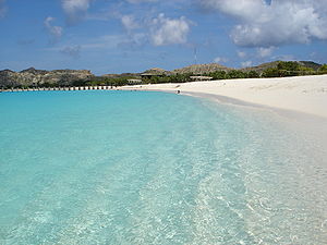
La Orchila ( Spanish Isla La Orchila ) is an island in the Caribbean Sea , about 180 km north of Caracas , the capital of Venezuela , and about 45 km east of Los Roques . Geographically, the island belongs to the islands under the wind , administratively to the Venezuelan Dependencias Federales (federal territories).
La Orchila has a land area of about 40 km² and reaches a height of 139 m above sea level on the Cerro Walker mountain. There are numerous beaches with pink sand on the island. There are some small cays in front of the island in the northeast .
The Venezuelan military operates a base on the otherwise uninhabited island, and there are quarters for the Venezuelan president and the military. Then President Hugo Chávez was imprisoned in La Orchila during the coup in April 2002 . Chavez also spent the last days on the island until his death.
Individual evidence
- ↑ Article on BBC Mundo.com (Spanish)
- ↑ Article on Focus.de. Retrieved June 30, 2015 .


