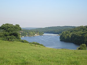
Lac de Rabodanges
| Lac de Rabodanges | ||
|---|---|---|

|
||
| Lac de Rabodanges | ||
| Geographical location | Orne , France | |
| Tributaries | Orne | |
| Drain | Orne | |
| Data | ||
| Coordinates | 48 ° 47 ′ 1 ″ N , 0 ° 17 ′ 14 ″ W | |
|
|
||
| surface | 1 km² | |
| length | 6 km | |
| width | 250 m | |
| Maximum depth | 12 m | |
The Lac de Rabodanges is a damming of the Orne , which is named after the nearby village Rabodanges . The lake, which lies in the middle of Norman Switzerland , was dammed in 1960. The Orne, which is dammed over a length of seven kilometers, drives a hydropower plant that has an output of 6500 kilowatts. The lake is inhabited by numerous fish, water birds and other animals. The lake extends over the territory of the former municipalities of Putanges-Pont-Écrepin , Sainte-Croix-sur-Orne , Les Rotours , Saint-Aubert-sur-Orne and Rabodanges, all of which became part of the new municipality of Putanges-le-Lac in 2016 .
Individual evidence
- ↑ General Part 1 ( Memento of the original from May 16, 2010 in the Internet Archive ) Info: The archive link was inserted automatically and has not yet been checked. Please check the original and archive link according to the instructions and then remove this notice.
- ↑ General Part 2 ( Memento of the original from March 8, 2009 in the Internet Archive ) Info: The archive link was automatically inserted and not yet checked. Please check the original and archive link according to the instructions and then remove this notice.
