
Lady Elliot Island
| Lady Elliot Island | ||
|---|---|---|
 |
||
| Waters | Coral sea | |
| Geographical location | 24 ° 7 ′ 0 ″ S , 152 ° 43 ′ 0 ″ E | |
|
||
| length | 870 m | |
| width | 670 m | |
| surface | 45 ha | |

The Lady Elliot Island is the southernmost coral island of the Great Barrier Reef before Australia's east coast. It is located 80 km northeast of Bundaberg in the Australian state of Queensland . The closest island to the south is Fraser Island, 83 km southeast . In the northwest, 37 km away, is the Bunker Group and the adjoining Capricorn Group , both island groups also part of the Great Barrier Reef. The island is around 45 hectares .
history
The Lady Elliot Island was discovered in 1816 and named after the ship of the discoverer. It has been open to tourism since 1970, trying to conserve nature as much as possible. A third of the island is a bird sanctuary and cannot be entered.
tourism

On the rest of the island, there are never more than 150 overnight guests at the same time. In the southeast of the island there is a small, comfortable holiday resort and a runway for small planes. Arrivals from Bundaberg, Hervey Bay and, more recently, Gladstone are all by air.
The island is particularly interesting for underwater sports enthusiasts. The breeding / hatching time for sea turtles is from October to December . Even whales can occasionally be observed there.
Bird life
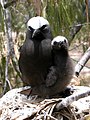
White cap noddi ( Anous minutus ) with nestling


Web links
- Website - Lady Elliot Island (English)
- Interactive aerial photograph of Lady Elliot Iceland (English)