
Cresta Lake
| Cresta Lake / Lag la Cresta | ||
|---|---|---|

|
||
| View from the north | ||
| Geographical location | canton of Grisons | |
| Tributaries | underground | |
| Drain | Flem → Vorderrhein | |
| Data | ||
| Coordinates | 743.61 thousand / 188 478 | |
|
||
| Altitude above sea level | 844 m above sea level M. | |
| surface | 5 ha | |
| length | 370 m | |
| width | 160 m | |
| volume | 300,000 m³ | |
| Maximum depth | 14 m | |

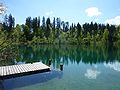
The Crestasee ( Rhaeto-Romanic : Lag la Cresta ) lies between Flims and Trin in the Swiss canton of Graubünden at an altitude of 844 m . With a little more than half of the area, it is in the municipality of Flims, the rest belongs to Trin. The name is derived from the Latin word crista for "terrain ridge". The Crestasee is therefore the “lake on the ridge of terrain” or on the range of hills. The lake can only be reached on foot or by bike.
Like the higher-lying Cauma lake, it lies in a hollow in the large forest of Flims. Its formation goes back to the Flims rockslide at the end of the last ice age.
location
The lake is surrounded by forest on three sides and is fed by underground springs. On the more open north side is the drain, which flows into the Flem via a threshold . Since the water level hardly changes over the course of the year, it is assumed that the same amount of water flows into the lake underground. The water temperature is slightly higher than that of Lake Cauma, which is probably due to the lower inflow of groundwater.
history
The Crestasee is mentioned for the first time around 500 years ago: In the marketing letter from 1461 the boundaries between the communities of Flims and Trin are described. The territory of the Freiherren von Sax-Misox , the heirs of the Lords von Freiherren von Belmont , should extend before the se uf and whether the se and into the forest to the egg, which is in the greatest tüffy lit, and from the same egg go to the Rin untz to the crooked wagon, even after the string . The stipulation that the boundary stones between the lake, Conn and the Krummenwaag on the Rhine should run in a dead straight line has remained valid to this day.
In 1805 the lake is said to have been populated by large pike, which, however, were not fished, but shot with shot from the shore and were brought ashore by dogs; fishing was prevented by numerous tree trunks in the water.
In the 19th century an attempt was made to drain the lake in order to gain cultivated land. An attempt in 1828 to divert the water through a tunnel failed. Around 1870, farmers from Trin succeeded in emptying three quarters of the lake. However, since the ground was covered with lime sinter and thus barren, no further drainage was planned.
At the end of the 19th century, the lake had regained its original size. It was also at that time that it was used for tourism. In 2001 and 2002 the Gasthaus Crestasee was renovated and a new building with changing rooms and toilets was built. The Crestasee is supervised by a lifeguard in the summer and entry is required during this time.
Media star
The lake appeared as a poster for the SBB , which advertised excursions into the untouched wilderness with a Canadian-style trapper with a dog and an absolutely undisturbed view over the lake and the large forest. In 2013 a picnic followed - with a fire, which is forbidden here - for a Migros family on Lake Crestasee, the long version of which smuggled an intro from Lake Cauma into the film.
gallery
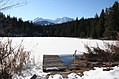
To the south

same place in May
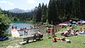
Bathing operation
May 2010

Drain


literature
- Emil Kirchen: When the mountain falls. The landslide area between Chur and Ilanz . Terra Grischuna et al., Basel et al. 1993, ISBN 3-7298-1087-1 .
Web links
- Cresta Lake
- Crestasee on schweizersee.ch
Individual evidence
- ^ Hermann Anliker: Schweizer Heimatbücher: Flims , Haupt-Verlag Bern 1961
- ^ Emil Kirchen: When the mountain falls: the landslide area between Chur and Ilanz ; Terra Grischuna, Chur 1993
- ↑ Our jewel - the Cresta Lake. Trin tourist office, accessed on July 4, 2020 .
- ^ The Migros picnic commercial 2013