Laguna de Términos

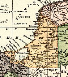
The Laguna de Términos is the largest lagoon lake on the south coast of the Gulf of Mexico in the state of Campeche . It was discovered by Juan de Grijalva as part of his exploration along the coasts of the Yucatán peninsula and adjacent areas to the west in 1518.
geography
The Laguna de Términos covers an area of around 2500 km² with a maximum length of approx. 75 km in east - west direction and a maximum width in north - south direction of 35 km. The average depth is approx. 3 m (max. 4.7 m).
The lagoon is separated from the Gulf of Mexico by the Isla del Carmen and northeast of it by the so-called Isla Aguada . The Isla del Carmen is a 35 km long and a maximum of 2.5 km wide spit island on which the city of Ciudad del Carmen lies and which over the bridges Puente Zacatal in the west with the mainland and Puente de la Unidad in the east with Isla Aguada , the westernmost foothills of the Peninsula El Palmar is connected. According to historical maps, there used to be an island in the area of Isla Aguada, but it was called Puerto Real Island or Isla Puerto Real .
The largest tributaries of the lagoon with two outlets are the Río Candelaria and the Río Palizada (eastern arm of the Río Usumacinta ).
Nature reserve
The entire lagoon - populated by well over 2000 animal and insect species - as well as other water and land areas (totaling over 7000 km²) were designated as a nature reserve by the Mexican government in 1994 . The shore zones of the lagoon are mostly made up of mangroves , below large parts of the water surface there are extensive seagrass meadows .
Web links
- Laguna de Términos - satellite photos + information (NASA, English)
- Laguna de Términos - Maps + Info (English)
- Laguna de Términos - Photos and information (English)
Individual evidence
Coordinates: 18 ° 36 ′ N , 91 ° 33 ′ W

