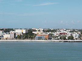
Ciudad del Carmen
| Ciudad del Carmen | ||
|---|---|---|
|
Coordinates: 18 ° 39 ′ N , 91 ° 50 ′ W Ciudad del Carmen on the map of Campeche
|
||
|
Location of Ciudad del Carmen in Mexico
|
||
| Basic data | ||
| Country | Mexico | |
| State | Campeche | |
| Municipio | Carmen | |
| City foundation | 1717 | |
| Residents | 169,466 (2010) | |
| City insignia | ||
| Detailed data | ||
| height | 10 m | |
| Post Code | 24100 | |
| prefix | 938 | |
| Time zone | UTC −6 | |
| Website | ||
Ciudad del Carmen is a city in the Mexican state of Campeche . It occupies the southwestern part of the Isla del Carmen , an island that delimits the Laguna de Términos to the Bay of Campeche (Gulf of Campeche, Gulf of Mexico ), off the coast of the Yucatán peninsula .
After the city could only be reached by ferry for years, it was connected to the eastern ( Puente de la Unidad ) and western ( Puente Zacatal ) mainland via two toll bridges in the 1990s . It is located about 215 miles southwest of Campeche and about 175 miles northwest of Villahermosa on the MEX-180 highway, which crosses the two bridges.
It has an international airport. The IATA airport code is CME .
The city likes to call itself the "Pearl of the Gulf".
Web links
Commons : Ciudad del Carmen - Collection of images, videos and audio files
- official website of the city ( Spanish )


