Lake Vermilion (Illinois)
| Lake Vermilion | ||
|---|---|---|

|
||
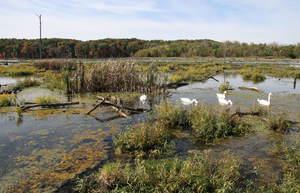
| Kennekuk Marshes, the wetland at the north end of the lake | ||
| Geographical location | Vermilion County in Illinois (USA) | |
| Tributaries | North Fork Vermilion River | |
| Drain | North Fork Vermilion River → Vermilion River → Wabash River | |
| Places on the shore | Danville | |
| Data | ||
| Coordinates | 40 ° 9 '22 " N , 87 ° 39' 8" W | |
|
|
||
| Altitude above sea level | 176 m | |
| surface | 4 km² | |
| length | 4.8 km | |
| width | 800 m | |
Lake Vermilion is a four square kilometer water reservoir in Vermilion County in the eastern part of the US state of Illinois . It was created for the purpose of supplying drinking water , fishing and recreation . The lake is around five kilometers long and just under a kilometer wide. The closest city is Danville - it's on the east and southeastern shores of the lake, and the closest highway exit is Exit 215 off Interstate 74 south of Danville. US Highway 136 runs on the eastern shore of the lake, less than a kilometer away.
The lake is mainly fed by the North Fork Vermilion River , which flows into the lake in the north and leaves it again in the southwest. A municipal road, Denmark Road , runs across a causeway and a short bridge across the lake; this is owned by Aqua Illinois , a subsidiary of Aqua America . Driving with boats , jet skis and water skis is permitted on the lake , although the power of the boat's engines is not limited.
fauna
The fish in Lake Vermilion species include bluegill , carp , Getüpfelter catfish , largemouth bass , muskellunge , walleye , annularis Pomoxis , Morone chrysops , Morone mississippiensis and yellow bullhead .
supporting documents
- ^ Illinois Atlas and Gazetteer . DeLorme Mapping, Freeport, Maine 1991, ISBN 0-89933-213-7 .
